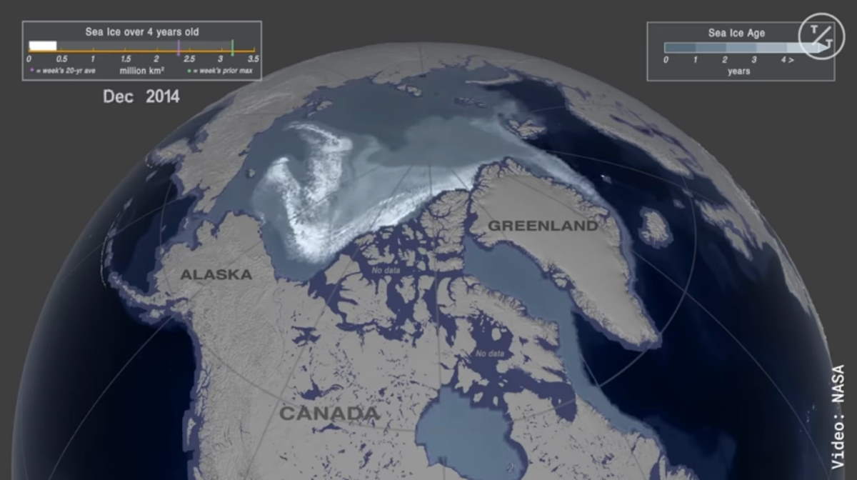
This NASA visualization shows a rapid decline in Arctic Sea ice over the last 35 years, based on satellite observations. The situation is really bad: in the 1st week of January 1988, over 1.2 million sq. miles (3.1 million km2) were covered by sea ice 4 years of age or older, compared with just over 44,000 sq. miles (114,000 km2) in the same week in 2019. Less than 5% once it was!
Arctic sea ice reaches its minimum each September. The 2012 sea ice extent is the lowest in the satellite record.
It likely reached its 2019 minimum extent on September 18. At 1.60 million square miles (4.15 million square kilometers), this year’s summertime extent is effectively tied for the second in the satellite record (tied with 2007 and 2016), since modern record-keeping began in the late 1970s, according to NASA and the National Snow and Ice Data Center.
The Arctic sea ice cap is an expanse of frozen seawater floating on top of the Arctic Ocean and neighboring seas. Every year, it expands and thickens during the fall and winter and grows smaller and thinner during the spring and summer.
But in the past decades, increasing temperatures have caused marked decreases in the Arctic sea ice extents in all seasons, with particularly rapid reductions in the minimum end-of-summer ice extent. The shrinking of the Arctic sea ice cover can ultimately affect local ecosystems, global weather patterns, and the circulation of the oceans.
Changes in Arctic sea ice cover have wide-ranging impacts. The sea ice affects local ecosystems, regional and global weather patterns, and the circulation of the oceans, according to NASA.

Sources
- Arctic Sea Ice Minimum on NASA.gov
- “2019 Arctic Sea Ice Minimum Tied for Second Lowest on Record” on NASA.gov

- How Many Elephants are Left in the World in 2025? - August 17, 2025
- Moon Landings: All-Time List [1966-2025] - February 2, 2025
- What Is Max-Q and Why Is It Important During Rocket Launches? - January 16, 2025