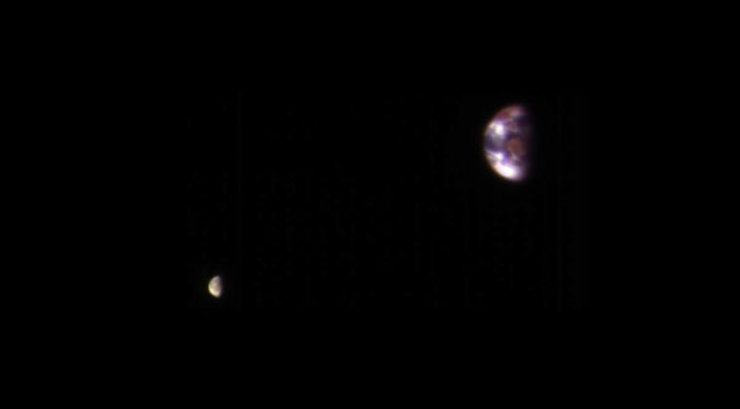
NASA published an amazing image of Earth (and the Moon) from Mars, taken on November 20, 2016, by the High-Resolution Imaging Science Experiment (HiRISE) camera on NASA’s Mars Reconnaissance Orbiter. The image is so incredibly detailed that we can see even the continents and clouds of Earth.

NASA published this amazing image on January 6, Friday. It is produced by combining two separate exposures taken on November 20, 2016. Alfred McEwen, a planetary geologist at the University of Arizona and the principal investigator of HiRise explained: “…because a good image of the moon saturates the Earth, and a good image of the Earth makes the moon appear too dark.” So, each exposure was separately processed before combining them so that the moon was bright enough to see.
The combined view retains the correct positions and sizes of the two bodies relative to each other. The distance between Earth and the moon is about 30 times the diameter of Earth. Earth and the moon appear closer than they are in this image because the observation was planned for a time at which the moon was almost directly behind Earth, from Mars’ point of view, to see the Earth-facing side of the moon.

The University of Arizona, Tucson, operates HiRISE (see notes 1), which was built by Ball Aerospace & Technologies Corp., Boulder, Colo. NASA’s Jet Propulsion Laboratory, a division of Caltech in Pasadena, California, manages the Mars Reconnaissance Orbiter Project for NASA’s Science Mission Directorate, Washington.
Notes
- The High-Resolution Imaging Science Experiment (HiRISE) camera is a 0.5 meters (1 foot and 8 inches) reflecting telescope, the largest ever carried on a deep space mission, and has a resolution of 1 microradian (μrad), or 0.3 meters (1 foot) from an altitude of 300 km (190 miles). In comparison, satellite images of Earth are generally available with a resolution of 0.5 meters (1 foot and 8 inches), and satellite images on Google Maps are available to 1 meter (3 feet and 3 inches).
- Mars Reconnaissance Orbiter (MRO) is a multipurpose spacecraft designed to conduct reconnaissance and exploration of Mars from orbit. It was launched on August 12, 2005, and attained Martian orbit on March 10, 2006. In November 2006, after five months of aerobraking, it entered its final science orbit and began its primary science phase.
Sources
- Mars Reconnaissance Orbiter on Wikipedia
- “Your Home Planet, as Seen From Mars” on the NASA website

- How Many Elephants are Left in the World in 2025? - August 17, 2025
- Moon Landings: All-Time List [1966-2025] - February 2, 2025
- What Is Max-Q and Why Is It Important During Rocket Launches? - January 16, 2025