A megatsunami is an exceptionally large and devastating wave that can reach incredible heights. Unlike regular tsunamis triggered by earthquakes, megatsunamis are primarily caused by massive landslides, volcanic eruptions, or asteroid impacts into bodies of water. These catastrophic events displace colossal amounts of water, generating waves that can travel across vast distances with tremendous force. The sheer magnitude of megatsunamis makes them particularly destructive, capable of impacting coastlines with devastating consequences. Their rare occurrence and immense power make megatsunamis a subject of great scientific interest and concern, as understanding their mechanisms and potential impacts is crucial for coastal regions and disaster preparedness.
Megatsunami is a different phenomenon than the tsunami
Megatsunamis have quite different features from tsunamis. Most ordinary tsunamis are caused by underwater tectonic activity: an earthquake occurs, and the seafloor rises and falls, causing a
Tsunamis have a small amplitude (wave height) offshore, and a very long wavelength (often hundreds of kilometers long, whereas normal ocean waves have a maximum wavelength of only 15 or 20 meters), which is why they generally pass unnoticed at sea, forming only a slight swell usually about 30 centimeters (12 in) above the normal sea surface.
As the tsunami approaches the coast and the waters become shallow, wave shoaling compresses the wave and its speed decreases below 80 kilometers per hour (50 mph). Its wavelength diminishes to less than 20 kilometers (12 miles) and its amplitude grows enormously. The water piles up to a wave height of up to about 10 meters/33 feet.

By contrast, megatsunamis can occur in locations where there is a very large amount of material that suddenly falls into the water (landslide), or anywhere in water (for meteor impact), or may be caused by volcanic activity, and can have extremely high initial wave heights of hundreds and possibly thousands of meters, far beyond any ordinary tsunami, as the water is “splashed” upwards and outwards by the impact or displacement. As a result, two heights are sometimes quoted for megatsunamis – the height of the wave itself (in water), and the height to which it surges when it reaches land, which depending upon the locale, can be several times larger.
Megatsunamis in the past
Now we know that a number of megatsunamis occurred in prehistoric, historic, and modern ages. For instance, approximately 66 million years ago, the asteroid which created the Chicxulub crater in Yucatán (scientists believe that this impact is the main cause of the extinction of numerous animal and plant groups, including non-avian dinosaurs) caused some of the largest megatsunamis in the Earth’s history: the waves should be as high as 5 kilometers (3.1 mi) and would have reached all the way to Texas and Florida.
About 2.5 million years ago, another asteroid impact in the southeast Pacific Ocean caused a megatsunami that was over 200 meters (660 feet) high in southern Chile and the Antarctic Peninsula; the wave swept across much of the Pacific Ocean.

Atlantis megatsunami?
In more recent times, some 3,600 years ago, the Minoan eruption (sometimes called the Thera eruption), which occurred at the height of the Minoan civilization (an Aegean Bronze Age civilization that arose on the island of Crete and other Aegean islands such as Santorini and flourished from approximately 3650 to 1400 B.C.).
The eruption left a large caldera surrounded by volcanic ash deposits hundreds of meters deep and may have led indirectly to the collapse of the Minoan civilization on the island of Crete, 110 km (68 miles) to the south, through a gigantic megatsunami. Another popular theory holds that the Thera eruption is the source of the legend of Atlantis.
Modern Age Megatsunamis
- In 1792, Mount Unzen in Japan erupted, causing part of the volcano to collapse into the sea. The landslide caused a megatsunami that reached 100 meters (330 feet) high and killed approximately 15,000 people in the local fishing villages.
- In 1883, The eruption of Krakatoa created pyroclastic flows which generated megatsunamis when they hit the waters of the Sunda Strait on 27 August 1883. The waves reached heights of up to 24 meters (79 feet) along the south coast of Sumatra and up to 42 meters (138 feet) along the west coast of Java. The explosions heard also remain the loudest noise on the human record. The sound was heard across the Indian Ocean, as far away as Rodriguez Island, 4,653 kilometers (2,891 miles) to the west, and Australia, 3,450 kilometers (2,144 miles) to the east.
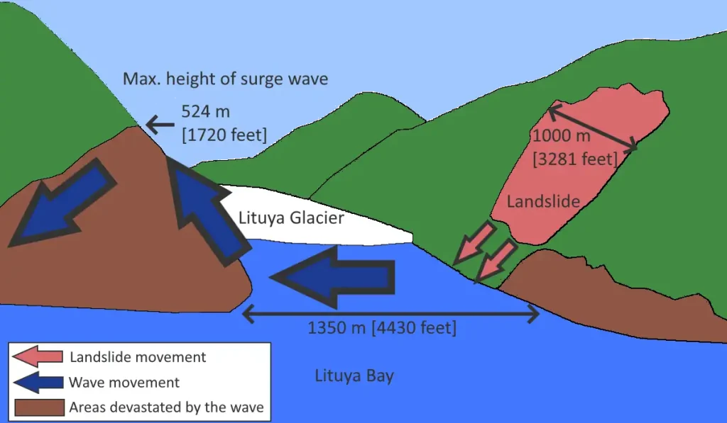
- On July 9, 1958, a giant landslide at the head of Lituya Bay in Alaska, caused by an earthquake, generated a wave with an initial amplitude of up to 520 meters (1,710 feet). This is the highest wave ever recorded, and surged over the headland opposite, stripping trees and soil down to bedrock, and surged along the fjord which forms Lituya Bay, destroying a fishing boat anchored there and killing two people. Howard Ulrich and his son managed to ride the wave in their boat, and both survived.
- On October 9, 1963, a landslide above Vajont Dam in Italy produced a 250 meters (820 feet) surge that overtopped the dam and destroyed the villages of Longarone, Pirago, Rivalta, Villanova, and Faè, killing nearly 2,000 people.
- On May 18, 1980, the upper 460 meters (1,509 feet) of Mount St. Helens collapsed, creating a massive landslide. This released the pressure on the magma trapped beneath the summit bulge which exploded as a lateral blast, which then released the over-pressure on the magma chamber and resulted in a
plinian eruption. One lobe of the avalanche surged onto Spirit Lake, causing a megatsunami that pushed the lake waters in a series of surges, which reached a maximum height of 260 meters (853 feet) above the pre-eruption water level (~975 m asl/3,199 feet). Above the upper limit of the tsunami, trees lie where they were knocked down by the pyroclastic surge; below the limit, the fallen trees and the surge deposits were removed by the megatsunami and deposited in Spirit Lake.
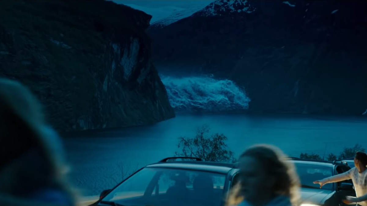
The Wave: a megatsunami movie
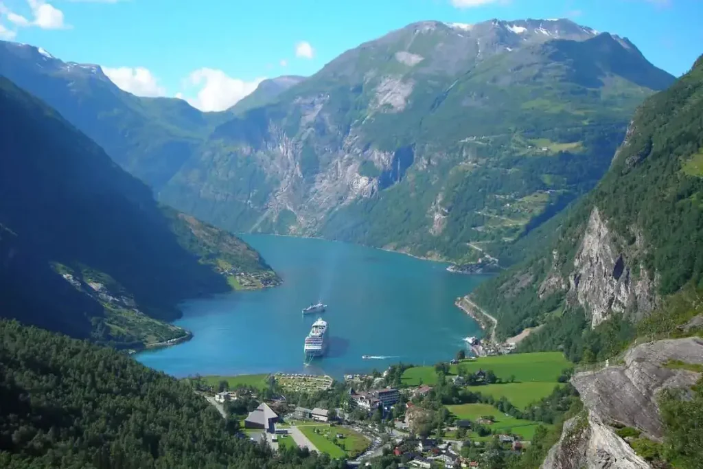
The 2015 Norwegian catastrophe drama film The Wave tells a fictional story about Geiranger, a small tourist village in the Sunnmøre region of Møre og Romsdal county in the western part of Norway. In the movie, the village threatened a huge mass of rock tumbles into Geirangerfjord (which is one of Norway’s most visited tourist sites, and it was listed as a UNESCO World Heritage Site in 2005). The rock sets off a 300-foot megatsunami. The villagers must rush to the mountains in ten minutes, before “the wave” reaches them.
Here is the trailer for the movie. Directed by Roar Uthaug (born 25 August 1973), it was Norway’s official submission for the Academy Award for Best Foreign Language Film at the 88th Academy Awards but it was not nominated.
The film is not completely fictional, in fact, Geiranger could be wiped out any second in real life. Norway is a rockslide-prone area and this has happened before, more than once: The Wave is based on a rock-slide tsunami (which is called a megatsunami) that washed over the villages of Fjørå and Tafjord in Møre og Romsdal on 7 April 1934.
Over forty people died. Prior to that in 1905, a similar incident again triggered a megatsunami killing 60 people, and 31 years later, another 74 lost their lives.
Sources
- Geiranger on Wikipedia
- Geirangerfjord on Wikipedia
- The Wave on IMDB
- The Wave (2015 film) on Wikipedia
- Megatsunami on Wikipedia
- Santorini on Wikipedia
- Chicxulub crater on Wikipedia

- How Many Elephants are Left in the World in 2025? - August 17, 2025
- Moon Landings: All-Time List [1966-2025] - February 2, 2025
- What Is Max-Q and Why Is It Important During Rocket Launches? - January 16, 2025