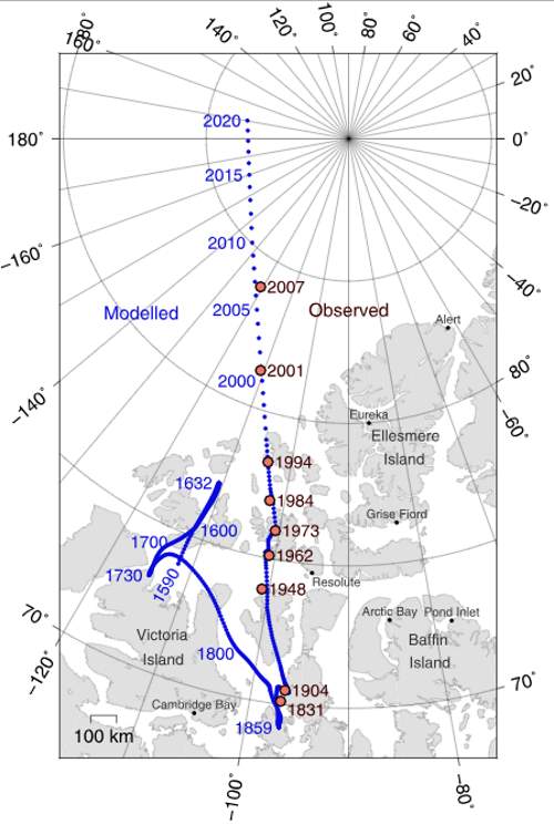
An interesting map showing the locations of the North Magnetic Pole since 1590. The North Magnetic Pole moves over time due to magnetic changes in the Earth’s core. Today, the Geographic North Pole (the point in the Northern Hemisphere where the Earth’s axis of rotation meets its surface, the northernmost point on the Earth) differs from the North Magnetic Pole by about 500 kilometers (311 miles).
If a magnetic compass needle is allowed to rotate about a horizontal axis, it would point straight down at the North magnetic
North Magnetic Pole locations since 1590 (map)

The magnetic North Pole moves in loops of up to 50 miles (80 km) per day. But its actual location, an average of all these loops, is also moving at around 25 miles a year.
In the last 150 years only, the magnetic pole has wandered a total of about 685 miles (1,102 kilometers).
The South Magnetic Pole also moves in a similar fashion. But, since the Earth’s magnetic field is not exactly symmetrical, unlike the geographic north and south poles, the North and South Magnetic Poles are not antipodal, meaning that a straight line drawn from one to the other does not pass through the geometric center of the Earth.
The direction in which a compass needle points is known as magnetic north. In general, this is not exactly the direction of the North Magnetic Pole (or of any other consistent location). Instead, the compass aligns itself to the local geomagnetic field, which varies in a complex manner over the Earth’s surface, as well as over time.
Historically, the magnetic compass was an important tool for navigation. So, how can you find the true north (geographic north) with a compass? The local angular difference between magnetic north and true north is called the magnetic declination.
Detailed maps typically tell you how much local deviation there is between magnetic north and true north (magnetic declination). You then offset your compass by that many degrees, and you’re all good. These types of maps (for example, military maps) are updated every few years or so.
To add to that, some maps in northern regions, such as Alaska, have numerous adjustments for deviations depending on what part of the map you are in.
Also in the Canadian Arctic pilots simply don’t use magnetic compasses because they’re too unreliable in the region.

Update: North Magnetic Pole officially has a new location
National Ocean and Atmospheric Administration (NOAA) has announced that:
Earth’s northern magnetic pole is moving quickly away from the Canadian Arctic toward Siberia. This movement has forced NCEI’s scientists to update the World Magnetic Model (WMM) mid-cycle.
Typically, a new and updated version of the WMM is released every five years. With the last release in 2015, the next version is scheduled for release at the end of 2019. Due to unplanned variations in the Arctic region, scientists have released a new model to more accurately represent the change in the magnetic field between 2015 and now.
This out-of-cycle update before next year’s official release of WMM2020 will ensure safe navigation for military applications, commercial airlines, search and rescue operations, and others operating around the North Pole.
Due to unplanned variations in the Arctic region, scientists have released a new model to more accurately represent the change in the magnetic field.
Why does the North Magnetic Pole move?
Earth’s inner core consists essentially of nickel and iron and has a radius of 1,220 km (760 mi). The density in the core is indicative of the fact that there must be heavy substances like gold, palladium, platinum, tungsten, and silver.
The temperature of the inner core is anticipated to be about 5,700 K (5,400 °C; 9,800 °F). Now, the reason why iron and other metals can remain solid at such high temperatures is that their melting temperatures drastically elevate at the pressure present at the core, which can roughly hover around 330 to 360 gigapascals.
The outer core, which has been found to be liquid (as per the seismic research), is 2300 km thick, and the radius extends around 3,400 km. The density is anticipated to be much higher than the crust or mantle, which varies between 9,900 and 12,200 kg/m3. The outer core is considered to be developed with 80% iron, along with nickel and some other lighter elements.
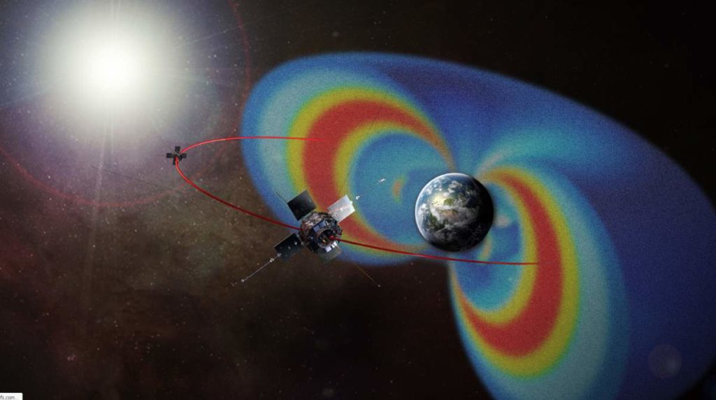
Due to its high temperature, the outer core remains in a low-viscosity fluid state that ensures turbulent convection and rotates quicker than the rest of the planet, creating a dynamo effect. This is what creates the Earth’s magnetic field.
The average strength of the magnetic field in Earth’s outer core is said to be 50 times the strength of the magnetic field recorded on the Earth’s surface.
The changes in the Earth’s magnetic field are the reason for the position shifts of the north and south magnetic poles. But it isn’t widely understood how and why this dynamo effect changes over time.
The main reason is most likely shifts in the rate of spin of the Earth’s outer core and the currents within the molten material.
Irregularities where the core and mantle meet can be another reason.
Large earthquakes can change the Earth’s crust and affect the rotation of Earth very slightly, so they can also cause small changes in the Earth’s magnetic field.
Geomagnetic reversal
The poles can also switch places. Over the life of the Earth, the orientation of Earth’s magnetic field has reversed many times, with magnetic north becoming magnetic south and vice versa – an event
Evidence of geomagnetic reversals can be seen at mid-ocean ridges where tectonic plates move apart and the seabed is filled in with magma. As the magma seeps out of the mantle, cools and solidifies into igneous rock, it is imprinted with a record of the direction of the magnetic field at the time that the magma cooled.
Sources
- North Magnetic Pole on Wikipedia
- Magnetic North vs Geographic (True) North Pole on GIS Geography website
- The North Pole on Wikipedia
- Why does the Magnetic North Pole move? on How Stuff Works
- “Earth’s Magnetic North Pole Has Officially Moved” on Forbes
- “World Magnetic Model Out-of-Cycle Release” on the National Ocean and Atmospheric Administration (NOAA) webpage
- How Many Elephants are Left in the World in 2025? - August 17, 2025
- Moon Landings: All-Time List [1966-2025] - February 2, 2025
- What Is Max-Q and Why Is It Important During Rocket Launches? - January 16, 2025


2 replies on “Locations of North Magnetic Pole since 1590”
Thank you: How much do you consider is science and what part is theory?
I realise this is an old topic, but your question needs an answer in order to avoid readers being as confused as you appear to be.
A theory I’m science is not a guess or an opinion, it is a robust explanation for natursl phenomena.
The process is as follows:
Someone creates an hypothesis to explain a phenomena, and offers evidence in support of it.
Others test this hypothesis by experimentation and observation.
If these consistently prove the hypothesis, then it becomes a scientific theory.
If not, then it is discarded.
Further, a scientific theory can be regarded as a fact in some circumstances.
For instance, gravity is both a fact, and a theory, because we don’t currently understand exactly HOW it works, but it is evident that it exists and behaves in a consistent manner.
I hope that helps you and any others stumbling across it in the future.