
Have you ever wondered where the rainiest place on Earth is? Our planet is unique in the solar system, as it’s the only one known to have liquid water on its surface – essential for all forms of life. Rain is a vital part of the water cycle, which moves water continuously on, above, and below Earth’s surface. It also deposits much of the freshwater we rely on. Let’s explore the top ten wettest places on Earth, where rain truly reigns.
Keep in mind that the list below features the top ten wettest locations on Earth based on available data. There may be even wetter places beyond the reach of direct scientific observation. Additionally, Earth’s climate is constantly changing, meaning some areas may become drier while others get wetter over time.
Top 10 Rainiest Places on Earth
10. Mount Emei, Sichuan Province, China
Average annual rainfall: 8,169 mm (321.60 inches)
Continent: Asia

Mount Emei is one of the four sacred Buddhist mountains in China and is known for its high levels of precipitation, making it one of the wettest places in the country. Located in the Sichuan Province, it has a unique climate because of its elevation, ranging from subtropical at the base to a sub-alpine climate at its peak.
The monsoons from the east and southeast are blocked by the mountain, which results in heavy rainfall, particularly in the warmer months. On average, the area gets rainfall an average of 255 days per year. Rainfall is especially heavy in summer, and more than 70% of the annual total occurs from June to September, as a result of the influence of the monsoon (see Notes 1 below).
This persistent rain contributes to the lush vegetation and rich biodiversity of the area, and it’s a crucial factor in shaping the area’s unique and beautiful landscape, from dense forests to its waterfalls.
The moisture and fog, particularly at the summit, are characteristic features of Mount Emei. This foggy, mystical environment is often referred to as the “Cloud Sea,” and it’s one of the key reasons that Mount Emei is a popular destination for tourists and nature lovers. However, it’s always important for visitors to be prepared for rain and changes in weather when planning a visit.
9. Pu’u Kukui, Maui, Hawaii
Average annual rainfall: 9,293 mm (365.87 inches)
Continent: Oceania
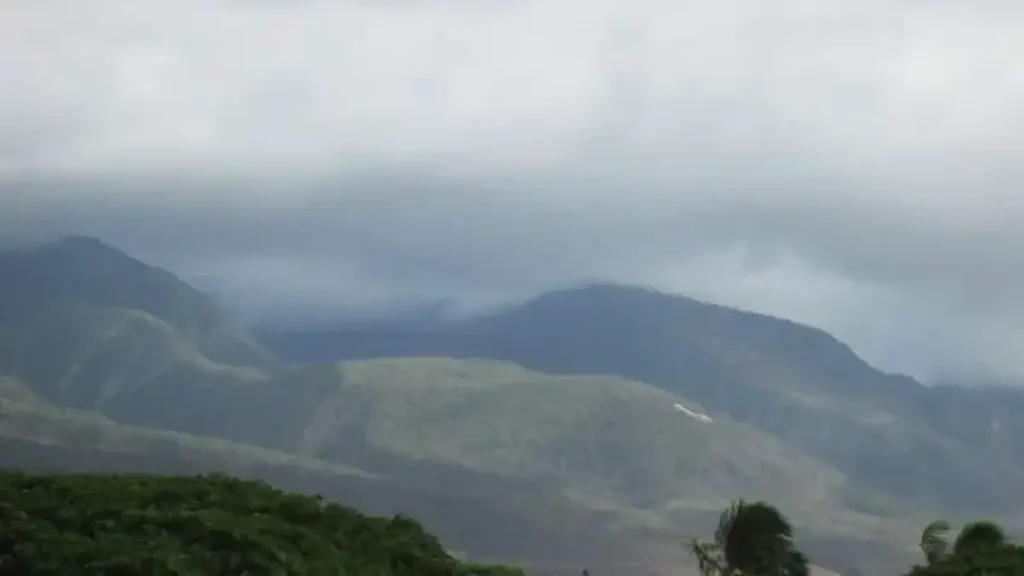
Pu’u Kukui is the highest peak of Mauna Kahalawai, more commonly referred to as the West Maui Mountains, located on the island of Maui in Hawaii. The name Pu’u Kukui means ‘Candlenut Hill’ in Hawaiian. With a height of 5,787 feet (1,764 meters), it is one of the most prominent features of Maui’s landscape. The mountain is notable for its stunning natural beauty, which includes lush forests, waterfalls, and a variety of rare and endangered plant and animal species.
One of the key features of Pu’u Kukui is its rainy weather. It is one of the rainiest spots on Earth. The area receives an average annual rainfall of about 365.87 inches (9,293 mm), but some years have seen rainfall totals exceeding 600 inches (15,240 mm). This heavy rainfall is largely due to the mountain’s location in the path of the trade winds and the elevation. When the moist air from the Pacific Ocean encounters the mountain, it’s forced upwards, which causes it to cool and condense, forming clouds and precipitating rain.
These abundant rains lead to the formation of numerous streams and waterfalls and contribute to the lush greenery of the surrounding valleys and forests. This environment has allowed the preservation of the diverse and unique ecosystem that thrives there. The Pu’u Kukui preserve is home to several endemic species, meaning they are found nowhere else in the world.
This area is managed by the Maui Land & Pineapple Company as a private nature preserve, and it’s largely closed off to the public to protect its fragile ecosystems. However, there are some opportunities for research and educational purposes. The incredible biodiversity and unique climate make Pu’u Kukui an important site for scientific study.
8. Mount Waialeale, Kauai, Hawaii
Average annual rainfall: 9,763 mm (384.37 inches)
Continent: Oceania

Mount Waialeale, located on the island of Kauai in the Hawaiian Islands, is one of the rainiest places on Earth. The name “Waialeale” in Hawaiian translates to “rippling water” or “overflowing water”, which is quite fitting considering the immense amount of precipitation it receives annually.
The mountain is a shield volcano, rising to an elevation of 5,148 feet (1,569 meters). The geological structure of the mountain, combined with its geographical location, contributes to its high rainfall.
There are several reasons why Mount Waialeale gets so much rain:
- Trade Winds: The Hawaiian Islands are located in a zone where trade winds, which predominantly blow from the northeast, are frequent. These winds bring moist air from the Pacific Ocean toward the islands.
- Orographic Lift: Mount Waialeale’s tall and steep slopes force incoming moist air upwards (a process known as orographic lift). As the air rises, it cools, condenses, and forms clouds, which subsequently leads to high levels of rainfall.
- Location: Its central location on the island of Kauai, which is the northernmost of the Hawaiian Islands, means that it’s often the first obstacle encountered by incoming winds and rain-bearing clouds.
The average annual rainfall on Mount Waialeale is around 9,763 millimeters (384.37 inches), although there have been years where the rainfall has exceeded this average considerably. For example, in 1982, Mount Waialeale saw a record 683 inches (17,300 mm) of rain. The area around the mountain is a lush, verdant rainforest, full of unique flora and fauna, which thrive in wet conditions.
Despite the allure of its greenery and waterfalls, Mount Waialeale’s summit is difficult to reach due to the treacherous landscape, dense vegetation, and, of course, the persistently wet and rainy weather. As such, it’s often only visited by experienced hikers and adventurers.
7. Big Bog, Maui, Hawaii
Average annual rainfall: 10,272 mm (404.40 inches)
Continent: Oceania

Big Bog is located on the island of Maui in the Hawaiian Islands, specifically near the eastern end of Maui’s Haleakala National Park, which is known for its unique and diverse ecosystems. As the name suggests, Big Bog is a wet, marshy area with an exceptionally high amount of rainfall.
Situated about 5,400 feet (1,600 meters) above sea level on the slopes of Haleakala, an enormous shield volcano that makes up more than 75% of Maui, Big Bog receives a lot of rainfall due to similar reasons to Mount Waialeale.
n terms of its annual rainfall, Big Bog, Maui is one of the rainiest places on earth. Reports vary, but the average annual rainfall is often cited as 404.40 inches (approximately 10,272 millimeters). This surpasses the averages of many other famously rainy locations around the world.
The area surrounding Big Bog is a lush, tropical rainforest that thrives under these wet conditions. The rainforest and the bog itself host a variety of unique ecosystems, with many endemic species that aren’t found anywhere else in the world. Despite the frequent rain, or perhaps because of it, the area attracts researchers, hikers, and nature enthusiasts who are eager to explore this vibrant and unique environment.
Big Bog is also the wettest spot in the United States:
“A team of scientists from the University of Hawaii-Manoa Geography Department has recently published a rainfall atlas to the state and may have discovered a new ‘wettest spot’ in the islands and thus for the entire United States. In 1992 they set up a rain gauge at a location known as the ‘Big Bog’ on the edge of Haleakala National Park on Maui Island. They had originally estimated the rainfall at this site to be on the order of 180” per annum, but the second year of data (1994) saw an amazing 560” of precipitation fall. The 30-year (1978-2007) average annual rainfall was 404″ at Big Bog (estimated from 1992-2007 data) vs. 393″ at Mt. Waialeale.”
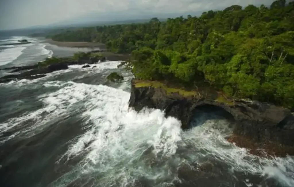
6. Debundscha point, Cameroon
Average annual rainfall: 10,299 mm (405.47 inches)
Continent: Africa

Debundscha Point, or Debundscha, is located in Cameroon, near the base of Mount Cameroon, which is one of Africa’s largest and most active volcanoes and the highest peak in Africa (4,040 meters / 13,250 feet). Due to its geographical position on the coast of the Atlantic Ocean and at the foot of Mount Cameroon, Debundscha is one of the wettest places on Earth.
Rainfall is influenced by multiple factors at this location. The southwest monsoon winds cause moisture-laden air to flow inland from the Atlantic Ocean. Upon encountering Mount Cameroon, this air is forced to rise, which cools it and leads to condensation and cloud formation, a process known as orographic precipitation.
This means that when winds hit the mountain, they rise and the moisture they carry condenses to fall as rain on the windward side of the mountain. This is why Debundscha, which is situated directly at the base of the mountain, receives such a high volume of rainfall.
The area has two main rainy seasons in a year, roughly corresponding to the periods of March to June and August to November. Average annual rainfall at Debundscha can exceed 10,299 millimeters (approximately 405.47 inches), though the precise amount can vary from year to year. It’s not uncommon for the region to experience heavy, persistent rainfall for several days at a time, contributing to its status as one of the wettest places on Earth.
5. San Antonio de Ureca, Bioko Island, Equatorial Guinea
Average annual rainfall: 10,450 mm (411.42 inches)
Continent: Africa
San Antonio de Ureca is a small village located on the Island of Bioko, Equatorial Guinea. The island is the northernmost part of the Republic of Equatorial Guinea. Similar to Debundscha in Cameroon, San Antonio de Ureca is also known for its heavy rainfall, making it one of the wettest places on Earth.
This substantial rainfall is largely due to the island’s location in the Gulf of Guinea and its mountainous topography. The moist air masses coming from the Atlantic Ocean are lifted by the island’s high mountains, leading to a high rate of condensation and, thus, rainfall. This process, known as orographic precipitation, is the same mechanism responsible for the high levels of rainfall at Debundscha.
Bioko Island experiences two rainy seasons in a year, and San Antonio de Ureca, being located on the southern coast of the island, bears the brunt of this precipitation. The village typically receives about 10,450 millimeters (411.42 inches) of rain annually, although the exact amount can vary year by year.
The dry season is from November to March, and the rest of the year heavy rainfalls.
The high rainfall makes the region lush and rich in biodiversity, providing a habitat for many unique plant and animal species.
4. Cropp River, New Zealand
Average annual rainfall: 11,516 mm (453.39 inches)
Continent: Oceania
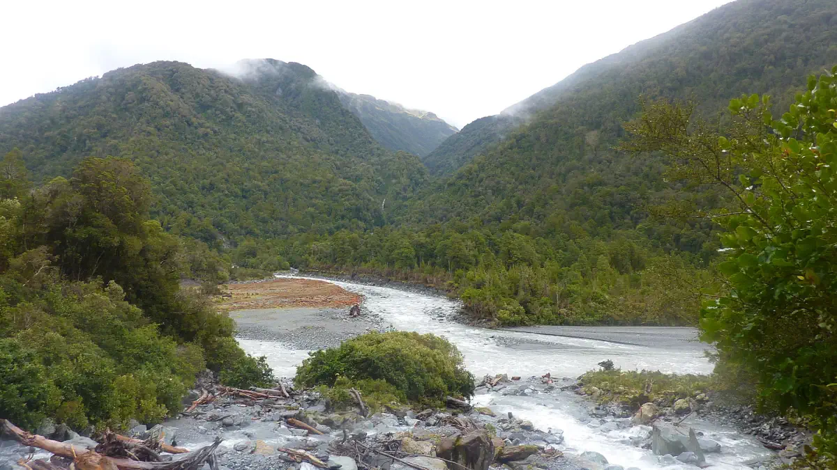
Cropp River is located on the west coast of New Zealand’s South Island, and it’s famous for recording some of the highest rainfall measurements in the world.
New Zealand’s west coast is known for its high rainfall due to the prevailing westerly winds that come off the Tasman Sea. When these moist winds reach the mountainous terrain, they’re forced upwards, which cools the air and causes the moisture to condense and fall as rain, a process known as orographic precipitation. This is the same mechanism that creates heavy rainfall in the areas like Debundscha and San Antonio de Ureca that we discussed earlier.
The Cropp River area, in particular, is well placed to receive a lot of this rainfall due to its location at the foot of the Southern Alps. The area’s steep slopes enhance the orographic effect, leading to even more rainfall.
The rainfall at Cropp River is astonishingly high. On average, the area receives around 11,516 millimeters (453.39 inches) of rain per year, although this can vary. The river holds the record for the most rainfall in New Zealand over a one-year period.
A specific incident of note is when the Cropp River recorded the highest 48-hour rainfall event in New Zealand. This happened on March 25-26 2019, when a staggering 1,086 millimeters (42.76 inches) of rain fell over two days. The area is not heavily populated due to the high rainfall, rugged terrain, and relative remoteness.
3. Tutunendo, Colombia
Average annual rainfall: 11,770 mm (463.39 inches)
Continent: South America

Tutunendo is a small municipality located in the Chocó Department on the west coast of Colombia. The region is known for its extreme rainfall, making it one of the wettest places on Earth.
The heavy rainfall in Tutunendo is largely a result of its geographical position near the equator and the Pacific Ocean. Warm, moist air masses from the Pacific Ocean are driven inland by prevailing winds. When this air encounters the Andean mountain range, it is forced to rise, leading to condensation and rainfall – a process known as orographic precipitation.
Tutunendo’s climate is characterized by a lack of distinct seasons; instead, there is heavy rainfall throughout the year. The area typically receives about 11,770 millimeters (463.39 inches) of rain annually, though the exact amount can vary from year to year.
Tutunendo is a tourist resort and township near Quibdó, whose name is derived from an Embera word meaning “river of fragrances.” The extreme rainfall is because the Andes to the east block the westerly winds driven by the Intertropical Convergence Zone which throughout the year, owing to the Humboldt Current off the west coast of South America, remains centered in the north of the continent at Tutunendo’s longitudes.
Quibdó holds the title of the wettest city in the world. Rain falls almost every day in intense thunderstorms, and sunny periods seldom last more than a few hours after sunrise.
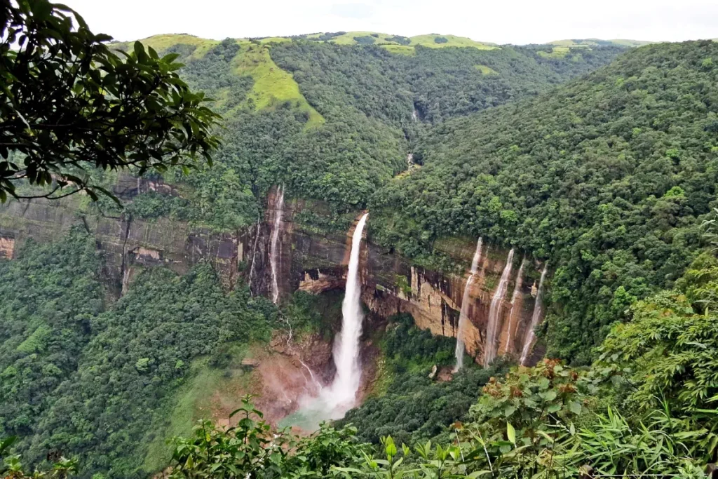
2. Cherrapunji (Cherrapunjee), Meghalaya State, India
Average annual rainfall: 11,777 mm (463.66 inches)
Continent: Asia

Cherrapunji, locally known as Sohra, is a town in the northeastern Indian state of Meghalaya. It’s well known around the world for its extreme rainfall, as it’s one of the wettest places on Earth. The town is situated on the southern part of the Khasi Hills, a dissected plateau at an elevation of about 4,290 feet (1,300 meters) above sea level, and it overlooks the plains of Bangladesh.
Cherrapunji holds several world records for its rainfall. The town receives an annual average rainfall of about 11,777 millimeters (463.7 inches), most of it falls during the monsoon season, which typically lasts from June to September. The town’s proximity to the Bay of Bengal and its location on the windward side of the Khasi Hills cause the area to receive substantial amounts of rain from the Southwest monsoon winds. The moist air rises over the hills, cools, and falls as rain.
Cherrapunji also holds the world record for the highest recorded rainfall in a single year: it received 26,471 millimeters (1,042.2 inches) of rain between August 1860 and July 1861. Additionally, it holds the record for the most rain in a single month: 9,300 millimeters (366 inches) in July 1861.
Despite the high amounts of rain, Cherrapunji faces an acute water shortage during the winter months. The heavy rainfall leads to severe soil erosion, stripping the ground of its topsoil and making it unsuitable for cultivation or the retention of water.
The heavy rain has also led to some unique adaptations. For example, the Khasi tribe, local to the area, has developed a tradition of growing “living bridges” from the roots of rubber trees to cross rivers and streams. These bridges can withstand heavy rains better than any human-made structure.

Visitors are often attracted to Cherrapunji’s impressive rainfall, but also its spectacular landscapes, waterfalls, and the living root bridges. Please note that while it’s a fantastic destination, the town can be difficult to reach, especially during the monsoon season, and infrastructure can be limited. As always, it’s recommended to plan ahead and research thoroughly before visiting.
1. Mawsynram, Meghalaya State, India. The wettest place on Earth.
Average annual rainfall: 11,871 mm (467.36 in)
Continent: Asia
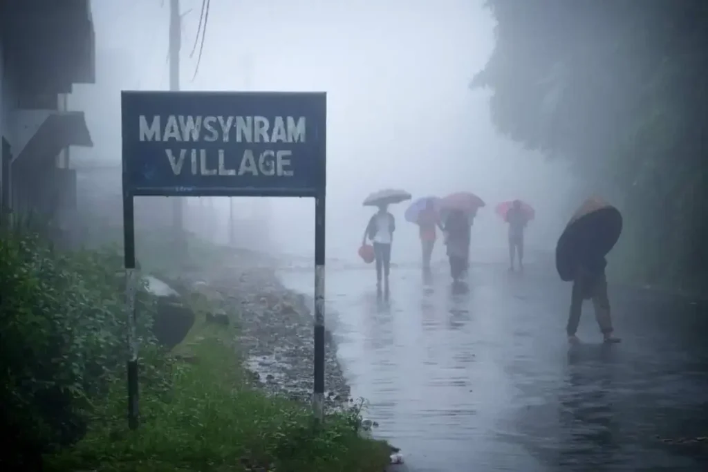
Mawsynram is a village in the East Khasi Hills district of Meghalaya state in northeastern India, located about 15 km west of Cherrapunji (Sohra). Mawsynram is known for receiving the highest recorded rainfall in the world, outpacing Cherrapunji, its well-known neighbor.
According to the Guinness World Records, Mawsynram received an incredible annual rainfall of 26,000 millimeters (1,000 inches) in 1985, the highest recorded in the world. The average rainfall in Mawsynram is about 11,871 millimeters (467.4 inches) per year, which varies slightly from year to year.
Like Cherrapunji, Mawsynram experiences the full force of the monsoonal winds from the Bay of Bengal, which get funneled over the village by its unique geographical location, leading to its extraordinary rainfall. These rains are primarily due to the summer monsoon winds that sweep over the steaming floodplains of Bangladesh and then are forced upward by the Khasi Hills, where they condense into clouds and rain.
Despite its excessive rainfall, Mawsynram, similar to Cherrapunji, faces a scarcity of drinking water in winter. The heavy rain leads to severe runoff and does not penetrate the soil, leading to water shortages once the monsoon season is over.
Interestingly, the villagers in Mawsynram use a unique type of grass to soundproof their huts from the deafening rain. They also use thick, knotted bamboo sheets to prevent rain from damaging their roofs.
Mawsynram’s terrain, like much of Meghalaya, is hilly and full of deep valleys where numerous species of flora and fauna flourish. It is also known for its huge formation of a stalagmite, which is shaped like a “Shivling” (a symbol of the Hindu deity Shiva), located in a cave known as “Mawjymbuin”.
Unofficial: Two “wettest place in the world” candidates
The claim that Mawsynram is the wettest place on Earth is disputed by Lloró, Colombia, which reported an average yearly rainfall of 12,717 millimeters (500.7 inches) between 1952 and 1989, and López de Micay, also in Colombia, which reported 12,892 millimeters (507.6 inches) per year between 1960 and 2012.
Tired of rain? See the Top 10 Driest Places on Earth
Notes
- A monsoon is traditionally defined as a seasonal reversing wind accompanied by corresponding changes in precipitation. Still, it is now used to describe seasonal changes in atmospheric circulation and precipitation associated with the asymmetric heating of land and sea. Usually, the term monsoon is used to refer to the rainy phase of a seasonally changing pattern, although technically there is also a dry phase. The major monsoon systems of the world consist of the West African and Asia-Australian monsoons. The inclusion of the North and South American monsoons with incomplete wind reversal has been debated. The term was first used in English in British India (now India, Bangladesh, and Pakistan) and neighboring countries to refer to the big seasonal winds blowing from the Bay of Bengal and the Arabian Sea in the southwest bringing heavy rainfall to the area. The southwest monsoon winds are called “Nairutya Maarut” in India. Extremely wet or dry events within the monsoon period have increased since 1980.
Sources
- Rain on Wikipedia
- Water cycle on Wikipedia
- Mount Emei on Wikipedia
- Monsoon on Wikipedia
- Pu’u Kukui on Wikipedia
- Mount Waialeale on Wikipedia
- Debundscha on Wikipedia
- San Antonio de Ureca on Wikipedia
- Cropp River on Wikipedia
- Tutunendo on colombia.travel
- Quibdó on Wikipedia
- Cherrapunji on Wikipedia
- Mawsynram on Wikipedia

- How Many Elephants are Left in the World in 2025? - August 17, 2025
- Moon Landings: All-Time List [1966-2025] - February 2, 2025
- What Is Max-Q and Why Is It Important During Rocket Launches? - January 16, 2025