
The ever-changing Earth: our planet is constantly changing over the years. Some changes are part of
The Aral Sea
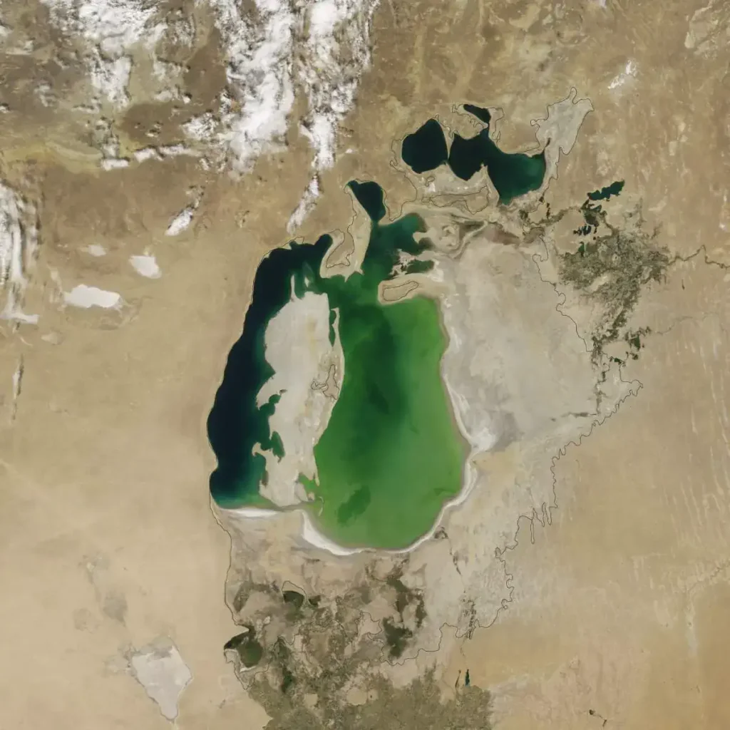
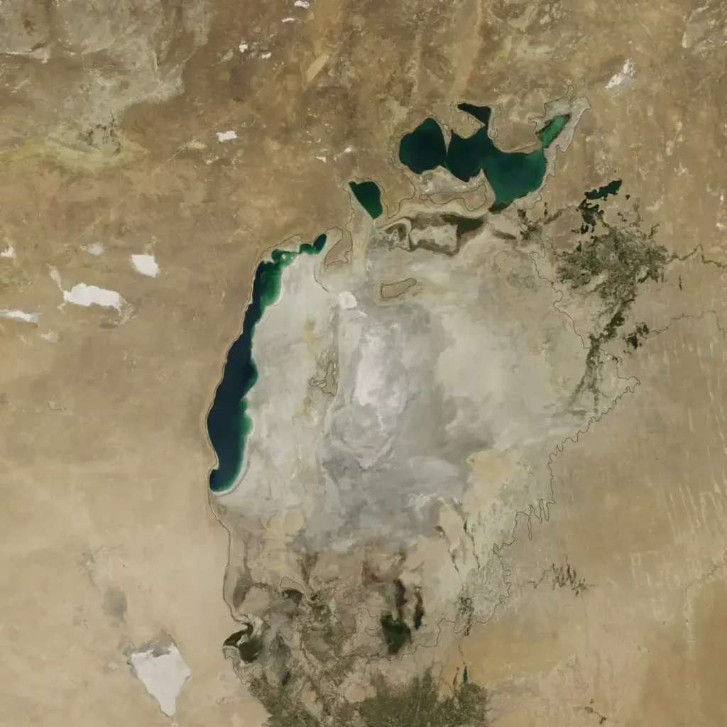
In 2000, the lake was already a fraction of its 1960 extent (black line). The Northern Aral Sea (sometimes called the Small Aral Sea) had separated from the Southern (Large) Aral Sea. The Southern Aral Sea had split into eastern and western lobes that remained tenuously connected at both ends.
Cause of the change:
In the 1960s, the Soviet Union undertook a major water diversion project on the arid plains of Kazakhstan, Uzbekistan, and Turkmenistan. The region’s two major rivers, fed by snowmelt and precipitation in faraway mountains, were used to transform the desert into farms for cotton and other crops.
Before the project, the Syr Darya and the Amu Darya rivers flowed down from the mountains, cut northwest through the Kyzylkum Desert, and finally pooled together in the lowest part of the basin. The lake they made, the Aral Sea, was once the fourth largest in the world.
The Ozone Hole
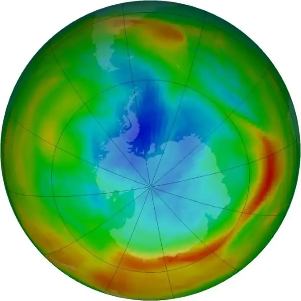
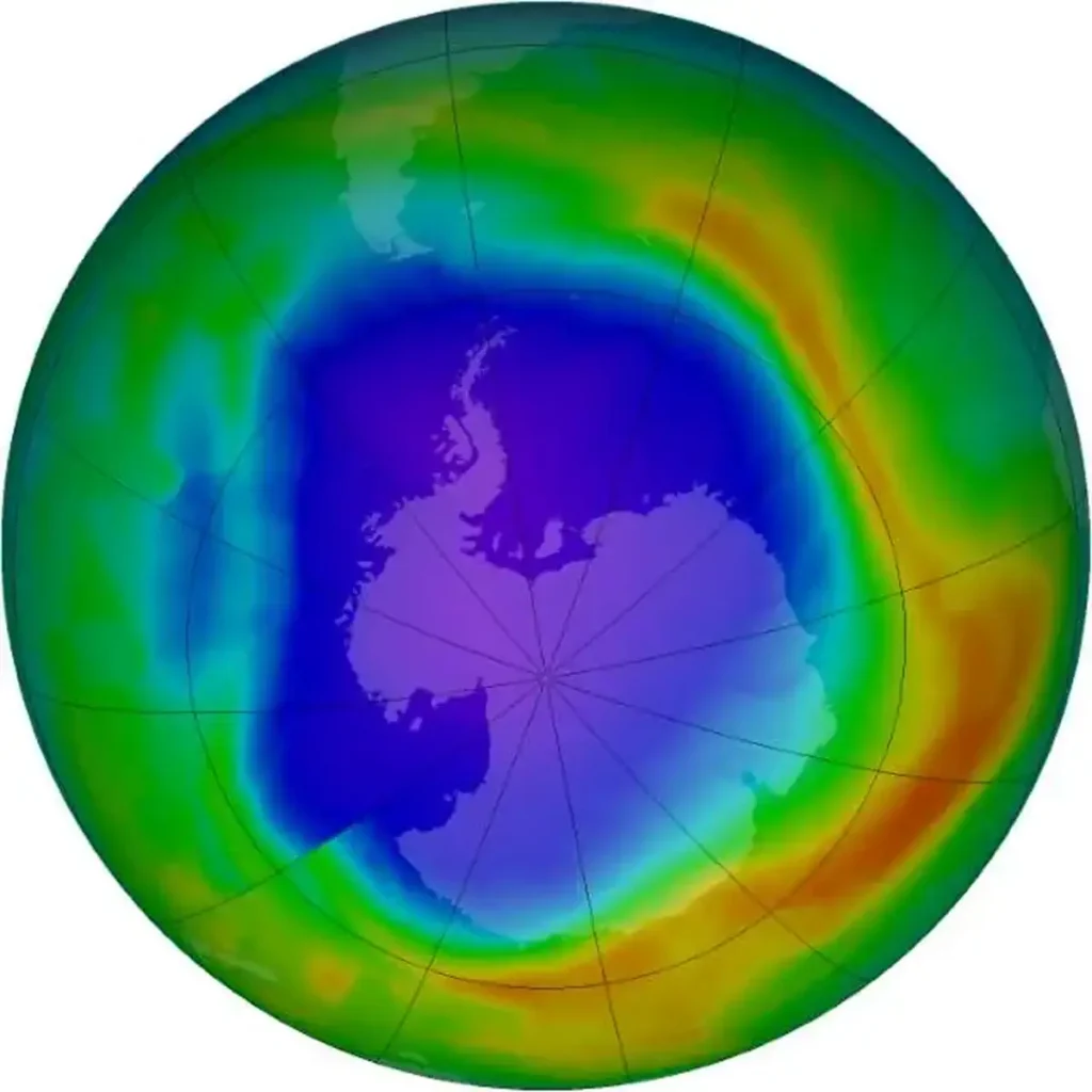
The stratospheric ozone layer protects life on Earth by absorbing ultraviolet light, which damages DNA in plants and animals (including humans) and leads to skin cancer. Prior to 1979, scientists had not observed concentrations below 220 Dobson Units.
But in the early 1980s, through a combination of ground-based and satellite measurements, scientists began to realize that Earth’s natural sunscreen was thinning dramatically over the South Pole each spring. This large, thin spot in the ozone layer came to be known as the ozone hole.
Purple and dark blue areas are part of the ozone hole.
Cause of the change:
It turned out that chlorofluorocarbons (CFCs), long-lived chemicals that had been used in refrigerators and aerosols sprays since the 1930s-had a dark side. In the layer of the atmosphere closest to Earth (the troposphere), CFCs circulated for decades without degrading or reacting with other chemicals.
When they reached the stratosphere, however, their behavior changed. In the upper stratosphere (beyond the protection of the ozone layer), ultraviolet light caused CFCs to break apart, releasing chlorine, a very reactive atom that repeatedly catalyzes ozone destruction.
Amazon Deforestation
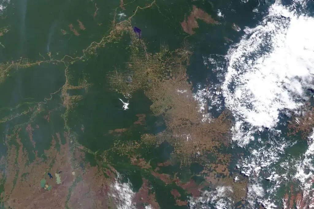
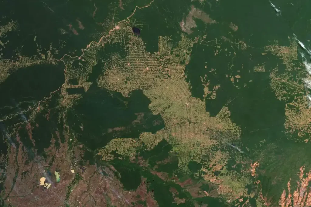
The state of Rondônia in western Brazil – once home to 208,000 square kilometers of forest (about 51.4 million acres), an area slightly smaller than the U.S. state of Kansas – has become one of the most deforested parts of the Amazon, the largest rainforest in the world.
In the past three decades, the clearing and degradation of the state’s forests have been rapid: 4,200 square kilometers cleared by 1978; 30,000 by 1988; and 53,300 by 1998. By 2003, an estimated 67,764 square kilometers of rainforest (an area larger than the U.S. state of West Virginia) had been cleared.
Cause of the change:
The first clearings that appear in the forest area in a fishbone pattern, are arrayed along the edges of roads. Over time, the fishbones collapse into a mixture of forest remnants, cleared areas, and settlements. This pattern follows one of the most common deforestation trajectories in the Amazon.
Legal and illegal roads penetrate a remote part of the forest, and small farmers migrate to the area. They claim land along the road and clear some of it for crops. Within a few years, heavy rains and erosion deplete the soil, and crop yields fall.
Farmers then convert the degraded land to cattle pasture
Urbanization of Dubai
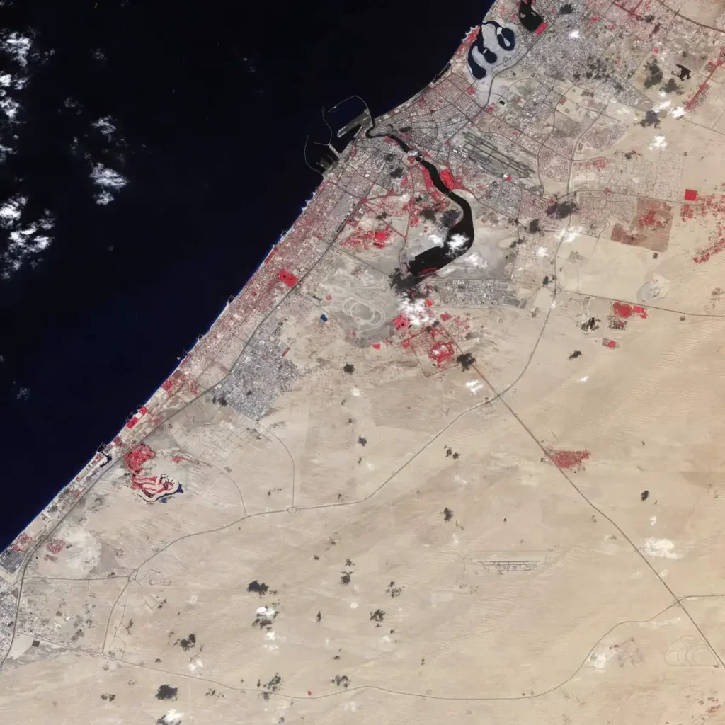

In these false-color images, the bare ground appears brown, vegetation appears red, water appears dark blue, and buildings and paved surfaces appear light blue or gray. The first image, acquired in November of 2000, shows the area prior to the island’s construction. As the years pass, urbanization spreads, and the final image shows the area almost entirely filled with roads, buildings, and irrigated land.
Cause of the change:
To expand the possibilities for beachfront tourist development, Dubai, part of the United Arab Emirates, undertook a massive engineering project to create hundreds of artificial islands along its Persian Gulf coastline. Built from sand dredged from the seafloor and protected from erosion by rock breakwaters, the islands were shaped into recognizable forms, including two large palm trees.
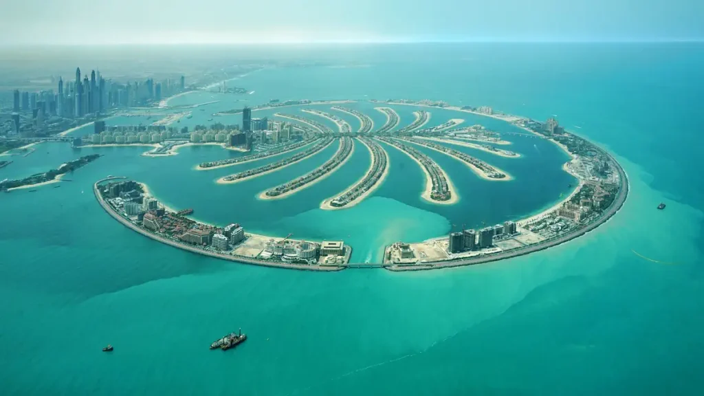
The Palm Islands are two artificial islands, Palm Jumeirah and Palm Jebel Ali, on the coast of Dubai, United Arab Emirates. As of November 2014, only Palm Jumeirah has been completed. This island takes the form of a palm tree, topped by a crescent. When complete, Palm Jebel Ali will take a similar shape; both islands will be host to a large number of residential, leisure, and entertainment centers and will add a total of 520 kilometers of non-public beaches to the city of Dubai.
The creation of the Palm Jumeirah began in June 2001. Shortly after, the Palm Jebel Ali was announced and reclamation work began. A third island was planned and construction started, but this project was later remodeled and renamed Deira Island.
Changing Earth: Google Timelapse
Google has launched a new website, Google Timelapse. The website provides an easy and free way to see how any location on Earth has changed since 1984. “Timelapse is a global, zoomable video that lets you see how the Earth has changed over the past decades. It is made from cloud-free annual mosaics, one for each year from 1984 to the current date, which are made interactively explorable by Carnegie Mellon University CREATE Lab’s Time Machine library, a technology for creating and viewing zoomable and pannable time-lapses over space and time.”
Sources
- World Of Change on the NASA Earth Observatory website
- Google Earth Engine Timelapse

- How Many Elephants are Left in the World in 2025? - August 17, 2025
- Moon Landings: All-Time List [1966-2025] - February 2, 2025
- What Is Max-Q and Why Is It Important During Rocket Launches? - January 16, 2025