A captured German V-2 rocket (V2 #13) took the first photo of Earth from space on October 24, 1946. The rocket was launched from the White Sands Missile Range carrying a 35mm motion picture camera onboard. The camera also recorded the first footage of Earth from space, snapping an image every second and a half.
Today’s (October 24) story of what happened this day in Science, Technology, Astronomy, and Space Exploration history.
The First Photo of Earth from Space
Long before the Soviet-made Sputnik truly began the space age in 1957, on October 24, 1946, the first photo of Earth from space was taken. The scientists launched a Nazi-built V-2 rocket (No. 13) from the White Sands Missile Range, a United States Army rocket range in southern New Mexico.
There was a camera aboard the rocket, and when the rocket reached 105 km (65 mi), just above the Kármán line, which is commonly accepted as the boundary between the Earth’s atmosphere and outer space. Kármán line lies at an altitude of 100 kilometers (62 mi) above the Earth’s sea level., where the photo was taken. The rocket was one of the V-2 rockets captured and moved to the US at the end of WWII.
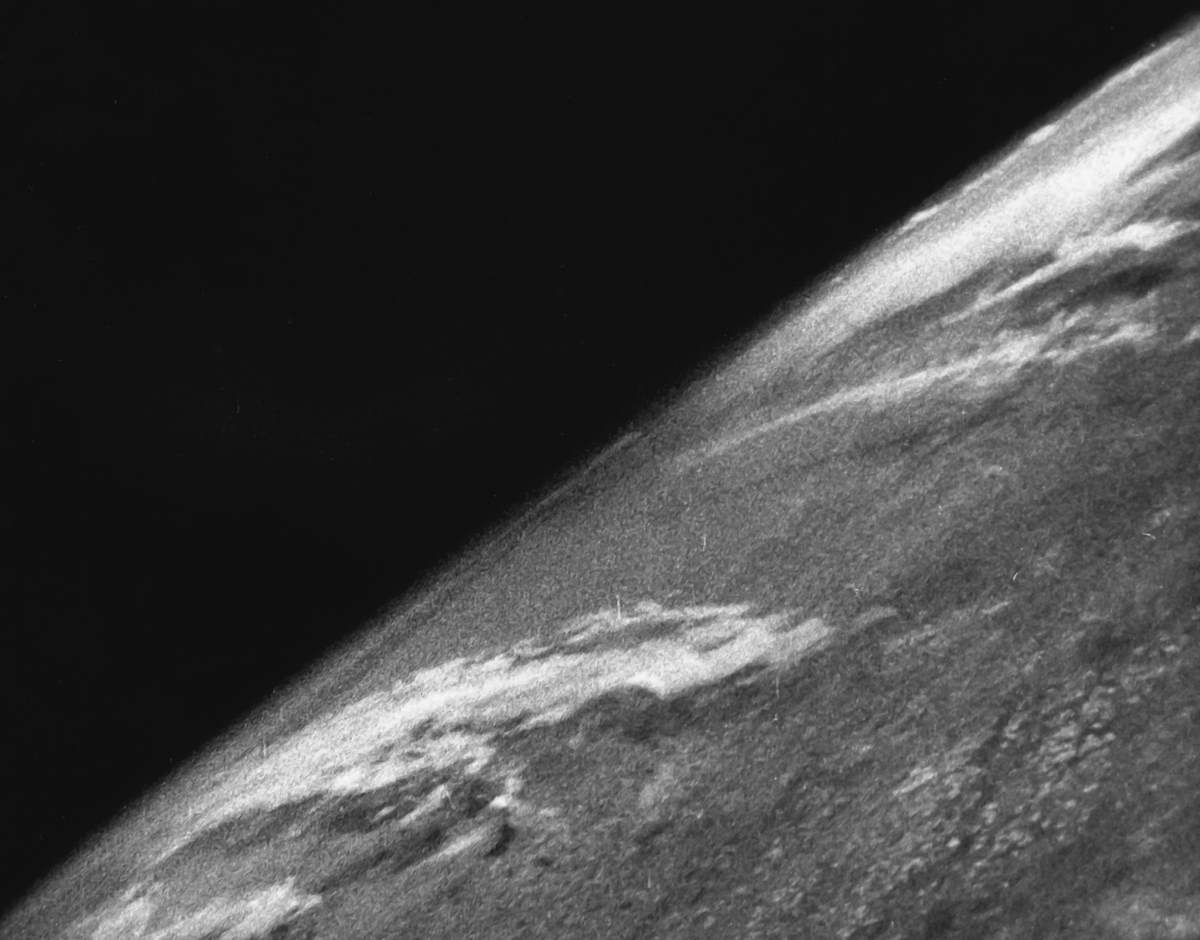
The V-2 rocket reached an altitude of 105 km (65.2 mi). Just a few minutes after the launch, its fuel expanded and the rocket fell back to Earth, sending the camera plummeting freely downward at some 500 feet per second (150 m/s). The impact destroyed the camera, but the film survived.
It took until the next day to recover the camera. It was smashed off, but the armored magazine inside survived. The grainy black-white images within, the first-ever taken of our planet from space, became a global phenomenon. Never before had human beings seen their world from this high.
The curvature of the Earth was clearly visible as were thick clouds over the American west.
Before 1946, the highest pictures ever taken of the Earth were from the U.S. high-altitude balloon Explorer II, which had ascended 13.7 miles (22 km) in 1935, high enough to discern the curvature of the Earth. The V-2 #13 camera reached more than five times that altitude, where they clearly showed the planet Earth set against the blackness of space.
Explorer II’s highest altitude was way down the Kármán line, so these pictures were not considered the first photos of Earth from space. But it was a crewed balloon, the two-man crew consisting of U. S. Army Air Corps Captains Albert W. Stevens (March 13, 1886 – March 26, 1949) and Orvil A. Anderson (May 2, 1895 – August 24, 1965) inside a sealed, spherical cabin. So, it was a very ambitious mission for its time.
Sources
- “The First Photo of Earth From Space” on the Smithsonian Magazine website
- Explorer II on Wikipedia

- How Many Elephants are Left in the World in 2025? - August 17, 2025
- Moon Landings: All-Time List [1966-2025] - February 2, 2025
- What Is Max-Q and Why Is It Important During Rocket Launches? - January 16, 2025