
A year after returning
With the voice of Jay Herman, EPIC lead scientist.
On July 20, 2015, NASA released to the world the first image of the sunlit side of Earth captured by the space agency’s EPIC camera on NOAA’s DSCOVR satellite. The camera has now recorded a full year of life on Earth from its orbit at Lagrange Point 1 (if you don’t know what a Lagrange Point is, please read on), approximately 1 million miles from Earth, where it is balanced between the gravity of our home planet and the sun.
EPIC takes a new picture every two hours, revealing how the planet would look to human eyes, capturing the ever-changing motion of clouds and weather systems and the fixed features of Earth such as deserts, forests, and the distinct blues of different seas. EPIC will allow scientists to monitor ozone and aerosol levels in Earth’s atmosphere, cloud height, vegetation properties, and the ultraviolet reflectivity of Earth.
The primary objective of DSCOVR, a partnership between NASA, the National Oceanic and Atmospheric Administration (NOAA), and the U.S. Air Force, is to maintain the nation’s real-time solar wind monitoring capabilities, which are critical to the accuracy and lead time of space weather alerts and forecasts from NOAA.
Video: An entire year of Earth from a million miles away
Deep Space Climate Observatory (DSCOVR) is orbiting the Sun-Earth L1 point (1,500,000 km / 930,000 mi from Earth, see the Lagrange points in the Sun-Earth system subtitle below) in a six-month period, with a spacecraft-Earth-Sun angle varying from 4 to 15 degrees.
Attached on it, EPIC (Earth Polychromatic Imaging Camera) takes a new picture every two hours, revealing how the planet would look to human eyes, capturing the ever-changing motion of clouds and weather systems and the fixed features of Earth such as deserts, forests, and the distinct blues of different seas. The camera has now recorded a full year of life on Earth from its orbit, seen here.
A million miles away, NOAA’s DSCOVR, the Nation’s first operational satellite in deep space, orbits a unique location called Lagrange Point 1, or L1. This orbit is a gravity-neutral point in space, allowing DSCOVR to essentially hover between the sun and Earth at all times, maintaining a constant view of the sun and the sun-lit side of Earth.
From here, the satellite can provide advanced solar measurements and early warnings of potentially dangerous space weather events, acting as a solar storm buoy in deep space.

Thanks to NASA’s EPIC imager, DSCOVR’s orbit also gives Earth scientists a unique vantage point for studies of the atmosphere and climate by continuously viewing the sunlit side of the planet.
EPIC provides global spectral images of Earth and insight into Earth’s energy balance. EPIC’s observations provide a unique angular perspective and are used in science applications to measure ozone amounts, aerosol amounts, and cloud height.
Lagrange points in the Sun-Earth system
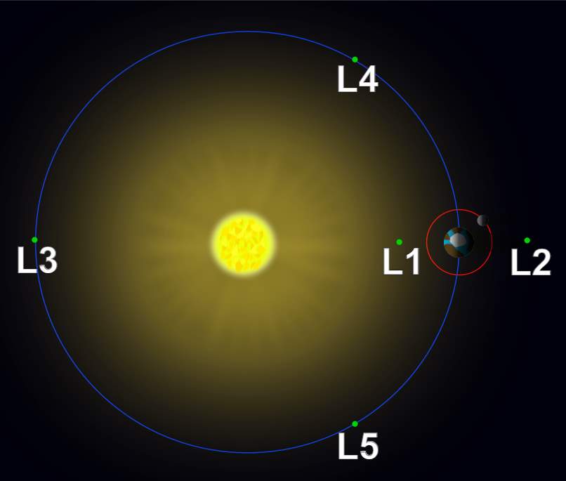
In celestial mechanics, the Lagrangian points are positions in an orbital configuration of two large bodies where a small object affected only by gravity can maintain a stable position relative to the two large bodies. The Lagrange points mark positions where the combined gravitational pull of the two large masses provides precisely the centripetal force required to orbit with them.
There are five such points, labeled L1 to L5, all in the orbital plane of the two large bodies. The first three are on the line connecting the two large bodies and the last two, L4 and L5, form an equilateral triangle with the two large bodies. The two latter points are stable, which implies that objects can orbit around them in a rotating coordinate system tied to the two large bodies.
For a very good explanation about the Lagrange points, see the video below.
The Lagrange Points are places where the forces acting on an object are perfectly balanced so that its orbit does not change. There are thousands of asteroids near Jupiter’s Lagrange points which are called the trojans.
Sources
- DSCOVR Captures an EPIC Year on nesdis.noaa.gov

- How Many Elephants are Left in the World in 2025? - August 17, 2025
- Moon Landings: All-Time List [1966-2025] - February 2, 2025
- What Is Max-Q and Why Is It Important During Rocket Launches? - January 16, 2025
2 replies on “A Year of Earth From a Million Miles Away [EPIC NASA video]”
Impressive, however how can there be no sight of the moon, only its shadow, when moon is ~240k miles from Earth and Epic is 1mil miles away?
Hi Charles! Thanks for your comment. The moon could be visible only if it had passed between the camera and the Earth, but in this video, it didn’t. Here’s a view of the moon transiting the Earth from EPIC.