![Devil's Pool [Victoria Falls]](https://ourplnt.com/wp-content/uploads/2016/07/Devil-Pool-Victoria-Falls.jpg)
Planet Earth, our home, is a mesmerizing kaleidoscope of natural oddities that often defy our understanding of the ordinary. From peculiar geographical formations to mystifying biological phenomena, it’s an array of wonderfully bizarre. Prepare to navigate ten of Earth’s strange places, each possessing its unique intrigue and awe-inspiring story, ready to challenge your perception of the world as you know it. Ready to discover the unexpected?
10 strange places [and sometimes scary] in the world
The Earth, our home has a lot of beautiful, amazing locations – and some strange places as well. These weird places sometimes look “impossible”, sometimes dangerous, and sometimes scary, but despite all that, still can be beautiful. Here are ten of these strange places in the world [with videos and images!].
1. The boiling river of the Amazon rainforest
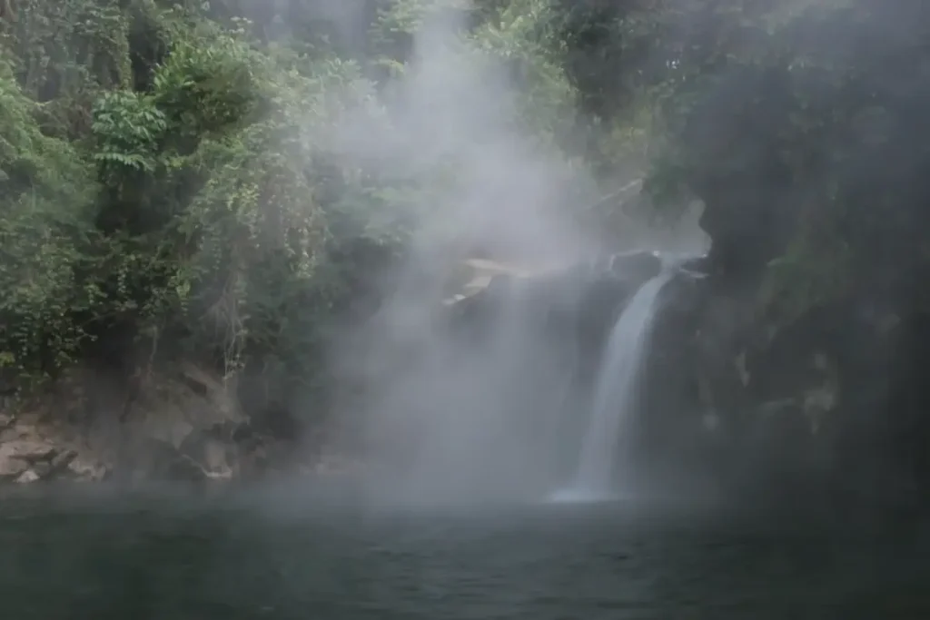
Our strange places list begins with the boiling river of the Amazon rainforest. Yes, it is “almost” boiling – with an average temperature of 86˚C (186.8˚F), the amazing river in Peru can boil you to death. It has been reported that sometimes animals fall into it, and die in a slow and really horrible way.
The river was a legend in the area for centuries. Its local name is Shanay-timpishka, which means “boiled with the heat of the Sun” in English. Peruvian geologist Andrés Ruzo had been fascinated with the myth since his childhood. In 2011, he made a trip to the Amazon rainforest with his aunt, and finally, his dream became a reality.
The river is huge (for a hot stream): up to 25 meters (82 feet) wide and six meters (20 feet) deep, and runs for 6.24 km (3.87
According to Ruzo, the chemical analysis carried out by him showed that the water is meteoric – this means the water originally fell as rain – to somewhere, the exact starting point is still unknown. After falling, probably the water going underground and going too deep. Then it is getting heated up by the geothermal energy of Earth. Then again going up to the surface, right into the Amazon rainforest.
Watch Andrés Ruzo’s TedX talk titled “How I found a mythical boiling river in the Amazon”.
2. The Draining Lake of Oregon [Lost Lake]
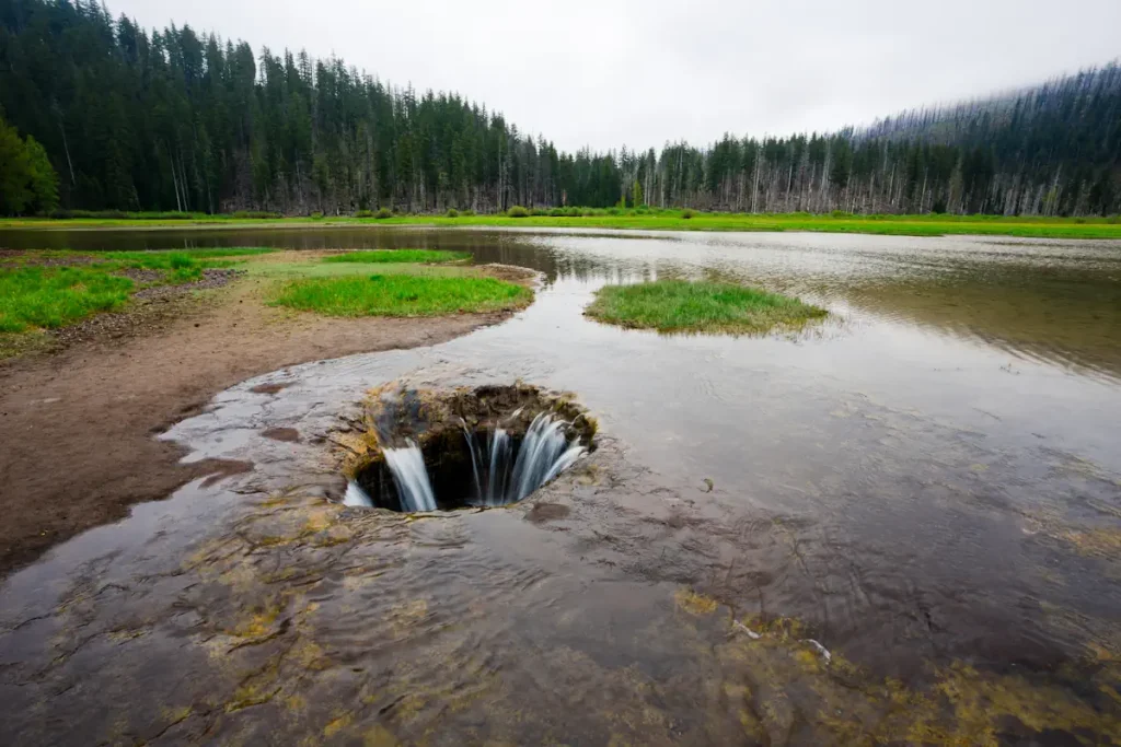
This mysterious Oregon lake is named “Lost Lake”, and once a year, it actually gets lost: it drains itself down a hole every year. The cause of this extremely rare phenomenon is a geological feature called a lava tube.
A lava tube is a natural conduit formed by flowing lava that moves beneath the hardened surface of a lava flow. Tubes can be actively draining lava from a volcano during an
But why does the lake gets lost only once a year? Because in the early spring, the water from the melting snow on top of the Cascade Range fills the lake faster than the hole can drain it. After most of the snow melts, the hole overcomes and the lake empties itself.
Lost Lake is located in the Mount Hood National Forest in the U.S. state of Oregon. The lake is known for its clear waters and the iconic view of Mount Hood, making it a popular destination for camping, fishing, and other recreational activities.
3. Mount Roraima of Venezuela, Guyana, and Brazil
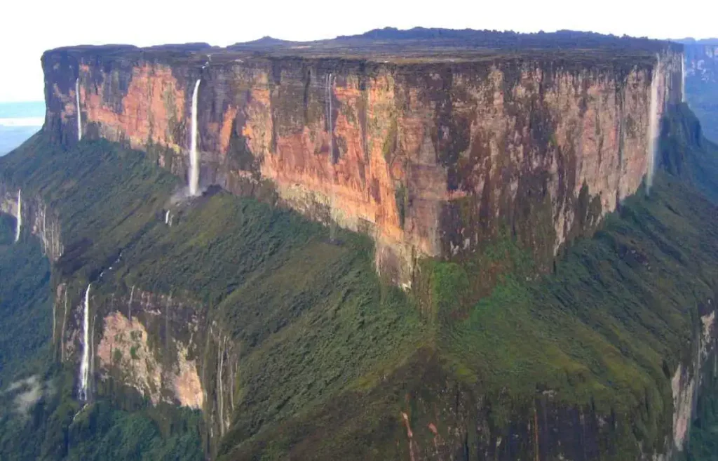
Mount Roraima is a natural wonder located in South America. It’s situated on the border of three countries: Venezuela (85% of its territory), Guyana (10%), and Brazil (5%). The mountain is part of the Pacaraima range and is known for its unique, flat-topped shape, also referred to as a tepui or “table-top mountain”. Mount Roraima is the highest of these plateaus in the Pacaraima range, with its highest point reaching approximately 2,810 meters (or about 9,219 feet) above sea level.
The mountain’s tabletop is encircled by 400-meter-tall cliffs creating an isolated and unique ecosystem above. It is home to several endemic species – those that are found nowhere else in the world. The isolation has allowed these species to evolve separately from the rest of the world.
Mount Roraima is known for its breathtaking vistas and unusual geological formations. The top of the mountain is dotted with unique, rocky formations, valleys, and caves. The frequent rains create a multitude of waterfalls that tumble down the sides of the tepui. Some of these waterfalls are among the highest in the world.
The mountain has long held significance to the indigenous people of the area and features prominently in their mythology. It’s considered to be the stump of a mighty tree that once held all the fruits and tuberous vegetables in the world.
In more recent popular culture, Mount Roraima gained fame as the inspiration for “Paradise Falls” in the Pixar film “Up”.
Trekking to the top of Mount Roraima is a popular adventure tourism activity. The most common approach is from the Venezuelan side, and the trek usually takes several days. Despite the challenges of the journey, including variable weather conditions and rugged terrain, hikers are rewarded with the opportunity to witness one of the world’s most unique and awe-inspiring landscapes.
4. North Sentinel Island of Bengal, Bangladesh
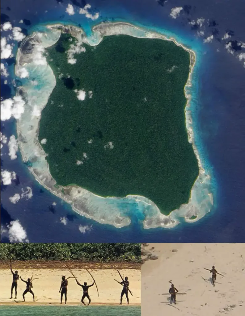
One of the strangest places in the world, the North Sentinel Island is one of the Andaman Islands in the Bay of Bengal. It lies to the west of the southern part of South Andaman Island. It is small, forested, located away from the main settlements on Great Andaman, surrounded by coral reefs, and lacks natural harbors.
The island itself isn’t strange. But, the inhabitants of it are. A group of indigenous people lives on North Sentinel Island – the Sentinelese. Their population is estimated to range from 50 to 500 individuals. The Sentinelese reject any contact with other people and are among the last people to remain virtually untouched by modern civilization. They are believed to be direct descendants of the first humans who emerged from Africa and have lived on the island for up to 55,000 years.
After the 2004 Indian Ocean tsunami, an Indian government helicopter confirmed that they were unaffected by the tsunami. Interestingly, they tried to fend off that helicopter by throwing stones and arrows. Although the tsunami disturbed the fishing grounds of the Sentinelese, they appear to have adapted to these changes.
On 26 January 2006, two fishermen were killed by Sentinelese when their boat drifted near the island.
In 2018, an American missionary, John Allen Chau, was killed by the tribe after illegally visiting the island with the intent of evangelizing them.
The first peaceful contact with the Sentinelese was made by Trilokinath Pandit, a director of the Anthropological Survey of India, and his colleagues on 4 January 1991. You can watch the event’s video below:
5. Jacob’s Well of Texas

Jacob’s Well is a perennial karstic spring (see notes 1) located in the Texas Hill Country, in the United States. Specifically, it can be found in the town of Wimberley, within Hays County. It’s the primary source of water for Cypress Creek that flows through Wimberley and feeds into the Blanco River.
The well has been a beloved swimming spot for generations, with its crystal-clear water providing a refreshing respite from the Texas heat. However, it’s also a significant site for ecological and hydrological study, as it’s an artesian spring that is connected to the Trinity Aquifer.
The mouth of the spring, often mistaken for a well due to its appearance, is an opening in the creek bed that is about 12 feet (about 3.6 meters) in diameter. The water in Jacob’s Well flows from an extensive network of underwater caves. The spring’s main cavern descends vertically for about 30 feet (9.1 meters), then continues downward at an angle through a series of silted chambers separated by narrow restrictions, finally reaching an average depth of about 120 feet (37 meters).
It’s worth noting that despite its beauty, Jacob’s Well is a dangerous place, especially for divers. The intricate network of underwater caves has led to several fatalities over the years, earning it the nickname of “the most dangerous diving spot in Texas.”
Today, the area around Jacob’s Well is managed as a nature center, known as the Jacob’s Well Natural Area, which features an art gallery, a nature center, picnic areas, and walking trails. Diving in Jacob’s Well is heavily regulated due to the inherent risks, and swimming is only allowed during certain periods of the year.
6. Devil’s Pool of Zambia [Victoria Falls]
![Strange places in the world: Devil's Pool [Victoria Falls]](https://ourplnt.com/wp-content/uploads/2016/07/Devil-Pool-Victoria-Falls-1024x576.jpg)
Victoria Falls is neither the highest nor the widest waterfall in the world, it is classified as the largest, based on its combined width of 1,708 meters (5,604 feet) and height of 108
For most of the year, anyone foolish enough to enter the waters would be instantly swept to their deaths. But in the dry season (usually between September and November), the reduced water levels create the world’s highest and most amazing infinity pool: the Devil’s Pool (also known as the Devil’s Swimming Pool). It is formed by a rock barrier at the edge of the falls. If you do not do something foolish, it is safe to swim in it if the water levels are reduced enough.
7. The Door to Hell of Turkmenistan

The “Door to Hell” is a renowned feature known as the Darvaza gas crater in Turkmenistan’s Karakum Desert. It originated from a drilling accident in 1971 when Soviet geologists unintentionally tapped into a cavern abundant with natural gas. This led to the collapse of the ground beneath their rig, forming a large crater.
To prevent the release of poisonous gases, the geologists decided to set the crater on fire, expecting the gas to burn off in a few weeks. However, the fire has been burning continuously since then, creating a captivating spectacle.
The diameter of the crater is 69 meters (226 feet), and its depth is 30 meters (98 feet). It emits a mesmerizing glow that is particularly striking at night.
Despite its remote location and harsh desert environment, the Door to Hell has gained international recognition as a tourist attraction. Turkmenistan, rich in natural gas reserves, showcases the Door to Hell as an example of its abundant resources. There have been discussions regarding the potential utilization of the gas reserves at the crater as an energy resource.
However, challenges such as the environmental impact and technical difficulties in extracting gas from such a remote and inhospitable location remain. The Door to Hell continues to enthrall visitors with its mysterious allure and the vast desert landscape that surrounds it.
8. The Devil’s Kettle of Minnesota
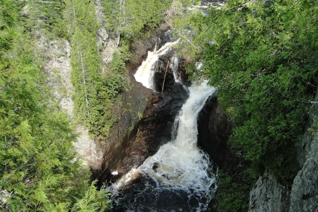
The Devil’s Kettle, located in Judge C. R. Magney State Park in Minnesota, is a fascinating and somewhat mysterious natural feature. It’s part of the Brule River, which splits into two at one point. One part continues on as a typical river, while the other part disappears into a large pothole, known as the Devil’s Kettle.
For many years, this has been the source of mystery and speculation. People have reportedly tossed various objects into the Devil’s Kettle, including logs, ping-pong balls, and even dye, but nothing ever seemed to come out the other side. This gave rise to numerous theories, including that the water somehow flows into an underground river or perhaps even into a different part of the world.
However, in 2017, hydrologists from the Minnesota Department of Natural Resources announced a likely explanation for the Devil’s Kettle. By measuring the volume of water upstream of the Devil’s Kettle and downstream where the river rejoins, they found no significant difference in the water volume. This suggests that the water reenters the Brule River not far downstream from the waterfall.
While the mystery of where the water goes may be solved, the Devil’s Kettle continues to captivate visitors with its unique and dramatic display of nature’s power.
9. Thor’s Well of Oregon
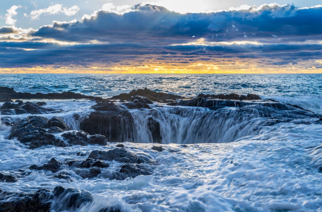
Thor’s Well is a unique and dramatic natural feature located in the Cape Perpetua Scenic Area of Oregon’s coast. It’s often referred to as a “sinkhole” or a “gate to the underworld.”
From a distance, it looks like a hole in the Pacific Ocean that’s continuously draining water. However, Thor’s Well is actually a hole in a rock formation that’s likely no more than 20 feet (6 meters) deep. It’s thought to have started out as a sea cave until the roof eventually collapsed, leaving the hole on top.
When the tide is high, particularly during winter storms, water surges up from the hole, creating a spectacle that attracts photographers and sightseers from around the world. As the wave recedes, it creates the illusion that the ocean is draining into the hole.
Despite its beauty, Thor’s Well can be dangerous, particularly at high tide or during stormy conditions, when powerful waves and currents can make it unsafe. Visitors are advised to maintain a safe distance and avoid turning their backs on the ocean.
Although not as widely known as some natural features, Thor’s Well is a remarkable sight that showcases the power and beauty of the Pacific Ocean.
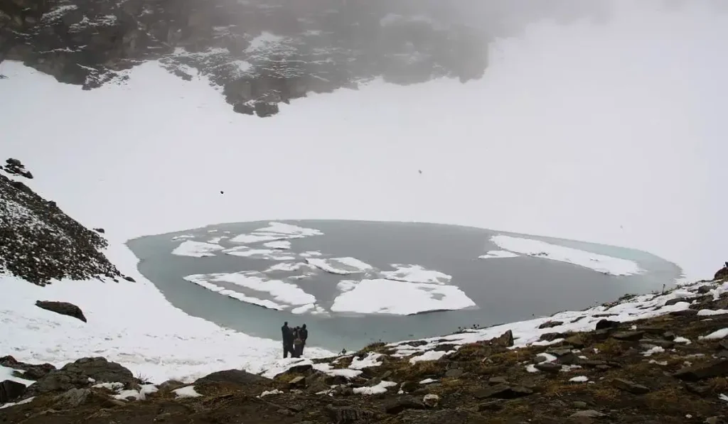
10. The Skeleton Lake of Roopkund, India
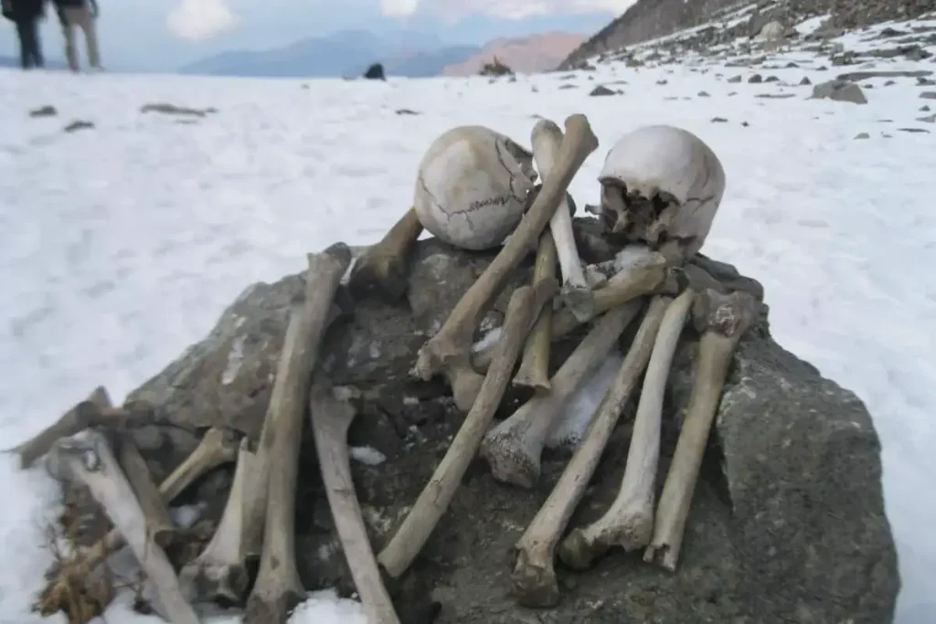
Having a depth of about two meters, Roopkund is a shallow, high-altitude glacial lake in the Uttarakhand state of India. The area is uninhabited, in the Himalayas at an altitude of 5,029 meters (16,499 feet).
Surrounded by rock-strewn glaciers and snow-clad mountains, the lake is a popular trekking destination. What makes the lake so strange? Hundreds of human skeletons were found at the edge of it. Because of these human remains, the lake has been called Skeleton Lake in recent times.
Why the skeletons are there, and who were these people? Many theories and opinions exist, from purely spiritual to scientific ones, attempting to explain the existence of these skeletons, which date back to the 9th century CE.
In 1942 a British forest guard in Nanda Devi National Park, Roopkund, made an alarming discovery: around and inside a frozen lake, there are a lot of skeletons. In the summer of 1942, the one-month period of ice melting revealed even more skeletons, floating in the water and lying haphazardly around the lake’s edges. Remnants belonging to more than 300 people have been found. Along with the skeletons, wooden artifacts, iron spearheads, leather slippers, and rings were also found.
When a team from National Geographic magazine retrieved about 30 skeletons, the flesh was still attached to some of them. Geneticists, Niraj Rai along with Manvendra Singh at the Center for Cellular and Molecular Biology at Hyderabad, conducted DNA tests on a hundred samples from the lake and compared them to the current Indian population.
Results indicated that 70 percent of them had an affinity with Iran, while the remaining belonged to the local population. It is hypothesized that the Iran group took the help of local porters to seek new land for settlement. Later studies placed the time of mass death around the 9th century CE (1,200 years old).
Local legend says that the King of Kanauj, Raja Jasdhaval, with his pregnant wife, Rani Balampa, their servants, a dance troupe, and others went on a pilgrimage to Nanda Devi shrine, and the group faced a storm with large hailstones, from which the entire party perished near Roopkund Lake.
What has not been determined is where the group was headed. There is no historical evidence of any trade routes to Tibet in the area, but Roopkund is on an important pilgrimage route of the Nanda Devi cult with Nanda Devi Raj Jat festivities taking place approximately once every twelve years.
Now, scientists believe they have finally solved the mystery of the skeletons: recent finds may lend some support to the local legend mentioned above. In 2013, researchers concluded that it is likely that the individuals had been killed in a hail storm.
The injuries on the remains indicate that each person was killed by one or more blows to the head, neck, and shoulders. There do not appear to be injuries on any other parts of their bodies, which rules out death by landslide, avalanche, or weapons.
As of today, the conclusion that this group of people died due to a severe hail storm remains the most plausible explanation as to what happened to them on their ill-fated journey. The hailstones, believed to be as large as cricket balls, would have caused fatal injuries to the people trapped in the valley with no shelter to escape to. However, there has been no verification as to whether this was a group traveling with the king of Kanauj, as the local legend states.
Despite its eerie reputation, Roopkund Lake is a popular trekking destination, known for its stunning and remote Himalayan landscapes. However, due to environmental concerns, trekking to Roopkund has been banned since 2019 by the Uttarakhand state government to protect the fragile ecology of the area.
Notes
- Karst topography is a landscape formed from the dissolution of soluble rocks such as limestone, dolomite, and gypsum. It is characterized by underground drainage systems with sinkholes and caves.
Sources
- Lava Tube on Wikipedia
- Mount Roraima on Wikipedia
- North Sentinel Island on Wikipedia
- Jacob’s Well (Texas) on Wikipedia
- Karst on Wikipedia
- Victoria Falls on Wikipedia
Door to Hell on Wikipedia- Judge C. R. Magney State Park on Wikipedia
- Cape Perpetua on Wikipedia
- Roopkund on W
ikipedia

- How Many Elephants are Left in the World in 2025? - August 17, 2025
- Moon Landings: All-Time List [1966-2025] - February 2, 2025
- What Is Max-Q and Why Is It Important During Rocket Launches? - January 16, 2025
One reply on “10 Strange Places on Earth [with Videos & Images!]”
devils kettle: i think it the water comes out of (small) springs in the ground. the water goes through lots of ground, which explains why the color dye doesn’t appear in the river below, that then lead to the river