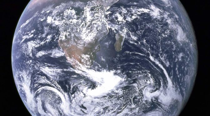
On December 7, 1972, the crewmembers of Apollo 17 spacecraft en route to the Moon took a photo of Earth from space, at a distance of about 45,000 kilometers (28,000 miles). This image, with the official NASA designation AS17-148-22727, became known as “The Blue Marble”. It remains one of the most iconic photos of Earth taken from space.

From the NASA website:
Blue Marble, the view of the Earth as seen by the Apollo 17 crew (astronaut Eugene A. Cernan, commander; astronaut Ronald E. Evans, command module pilot; and scientist-astronaut Harrison H. Schmitt, lunar module pilot) traveling toward the moon. This translunar coast photograph extends from the Mediterranean Sea area to the Antarctica south polar ice cap.
This is the first time the Apollo spacecraft trajectory made it possible to photograph the South polar ice cap. Note the heavy cloud cover in the Southern Hemisphere. Almost the entire coastline of Africa is clearly visible. The Arabian Peninsula can be seen at the northeastern edge of Africa. The large island off the coast of Africa is the Malagasy Republic. The Asian mainland is on the horizon toward the Northeast.
Blue Marble and the Environmentalism Movement
This image, with the official NASA designation AS17-148-22727, became known as “The Blue Marble”, quickly became of the most iconic photos of Earth from space.
In fact, it was not the first clear image of Earth taken from space – similar photos had already been taken as early as 1967. For example, the uncrewed Apollo 4 spacecraft also took spectacular images of Earth from space in 1967.
But, the 1970s were the scene of a big surge in environmental activism. On April 22, 1970, the first “Earth Day” was organized by Gaylord Nelson, former senator of Wisconsin, and Denis Hayes, a Harvard graduate student. Millions of people gather in the United States for the event.
So, Apollo 17 image AS17-148-22727 nicknamed the “Blue Marble” went “viral” in today’s terms, and became a symbol of the environmental movement, as a depiction of Earth’s frailty, vulnerability, and isolation amid the vast expanse of space. According to NASA archivist Mike Gentry, it is among the most widely distributed and reproduced images in human history.
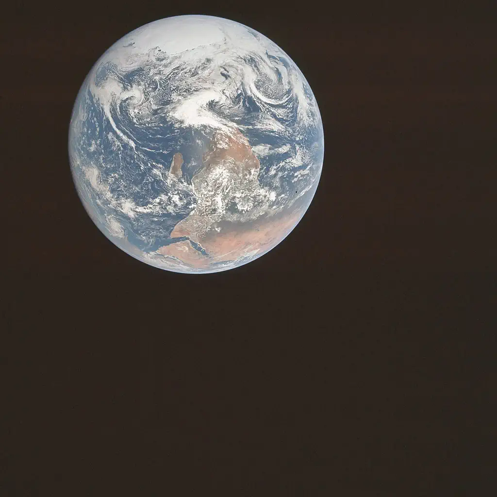
The unedited blue marble photo, AS17-148-22727
The widely published versions are cropped and chromatically adjusted from the original photograph taken by the Apollo 17 crew. The photograph’s original orientation had the south pointed up. But it is flipped vertically before being published because people are more accustomed to north-up images of Earth.
The Black Marble
On December 5, 2012, using the data was acquired by the Suomi NPP satellite in April and October 2012, NASA released a nighttime view of Earth – and it was called the “Black Marble“, after the “Blue Marble”. The images taken at nighttime were mapped over existing Blue Marble imagery of Earth to provide a realistic view of our home planet.
The new “Blue Marble”
On July 21, 2015, NASA released a new Blue Marble photograph taken by solar weather and Earth observation satellite U.S. Deep Space Climate Observatory (DSCOVR), see the post titled EPIC Earth Image by NASA. The image was taken on July 6, 2015.
The photograph, taken by NASA’s Earth Polychromatic Imaging Camera (EPIC), a four-megapixel CCD camera and telescope, of the Western Hemisphere, is centered over Central America. The Western United States, Mexico, and the Caribbean are visible, but much of South America is hidden beneath the cloud cover. Greenland can be seen at the upper edge of the image.


Sources
- The Blue Marble on Wikipedia
- Apollo 17 on Wikipedia
- Blue Marble – Image of the Earth from Apollo 17 on the NASA website

- How Many Elephants are Left in the World in 2025? - August 17, 2025
- Moon Landings: All-Time List [1966-2025] - February 2, 2025
- What Is Max-Q and Why Is It Important During Rocket Launches? - January 16, 2025