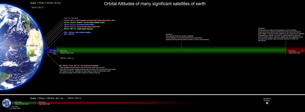
Here are the orbital altitudes of many significant satellites (both artificial and natural – the latter only being the Moon) of Earth.

Click/tap on the image to see it in full size.
Satellites and their orbital altitudes in the image
Sub-orbit
- 0 km/mi: sea level
- 37.6 km (23.4 mi) – Altitude record for an airplane. Russian pilot Alexandr Fedotov (June 23, 1932 – April 4, 1984) holds the world altitude record for a self-propelled airplane: on August 31, 1977, Fedotov’s MiG E-266M reached an altitude of 37.6 km / 23.4 mi (123,523 feet). In fact, on July 17, 1962, American test pilot Robert White (July 6, 1924 – March 17, 2010) took the X-15 to an altitude of 314,688 feet, but, the X-15 didn’t take off under its own power, it was carried aloft by a modified B-52. So, the “world altitude record for a self-propelled airplane” record belongs to Fedotov.
Low Earth Orbit (LEO)
A low Earth orbit (LEO) is an Earth-centered orbit with an altitude of 2,000 kilometers (1,200 mi) or less (approximately one-third of the radius of Earth), or with at least 11.25 periods per day (an orbital period of 128 minutes or less).
Orbital altitudes of the significant satellites in the Low Earth Orbit
- 215 km (133.6 mi) – Sputnik 1, the first artificial satellite of Earth. Launched on October 4, 1957, it orbited the Earth until January 4, 1958, made 1440 orbits, and traveled about 70 million kilometers (43 million miles).
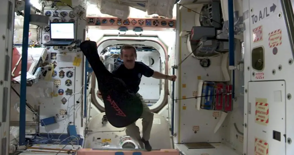
- 370 km (230 mi) – Former Soviet/Russian space station Mir. At Mir’s orbital altitude, the force of Earth’s gravity was 88% of sea-level gravity. So, the onboard environment was not one of weightlessness or zero gravity. But, the constant free fall of the station offered a perceived sensation of weightlessness – this is often described as microgravity.

Related: What is an orbit?
- 405 km (251.6 mi) – The International Space Station. The flight rule limits are a minimum altitude of 280 km (174 mi) and a maximum altitude of 460 km (285 mi). Operationally, it tends to maintain a narrower band.
- 540 km (340 mi) – Hubble Space Telescope. This vantage point allows it to obtain a view of cosmic objects unobstructed by Earth’s atmosphere, which can distort light and block certain wavelengths.
- 600-800 km (372.8-497.1 mi) – Sun-Synchronous Satellites. These satellites orbit Earth in near-exact polar orbits north to south. They cross the equator multiple times per day and each time they are at the same angle with respect to the Sun. Satellites on these types of orbits are particularly useful for capturing images of Earth’s surface or images of the Sun.
- 700-1700 km (435-1056 mi) – Polar-Orbiting Environmental Satellites (POES). A polar orbit is one in which a satellite passes above or nearly above both poles of the body being orbited on each revolution. Different types of satellite orbits have different uses: while the synchronous orbit is best for communication satellites, Lagrangian point orbits help monitor the solar wind before it reaches Earth. A low-altitude polar orbit is widely used for monitoring the Earth because each day, as the Earth rotates below it, the entire surface is covered. Spacecraft avoid polar orbits because flying through the aurora exposes astronauts to radiation and creates other problems.

Related: Why do Astronauts Float in Space?
Medium Earth Orbit (MEO)
Medium Earth orbit (MEO), sometimes called intermediate circular orbit (ICO), is the region of space around Earth above low Earth orbit and below geosynchronous orbit (altitude of 35,786 km or 22,236 mi above sea level).
Orbital altitudes of the significant satellites in the Medium Earth Orbit
- 20,350 km (12,645 mi) – Global Positioning System (GPS) satellites. Over 30 GPS navigation satellites are orbiting the Earth at the Semi-Synchronous Orbit (SSO) meaning that their orbital period is 12 hours (twice per day).
Geosynchronous Orbit
A geostationary orbit, geostationary Earth orbit, or geosynchronous equatorial orbit (GEO) is a circular orbit 35,786 kilometers (22,236 mi) above the Earth’s equator and following the direction of the Earth’s rotation. An object in such an orbit has an orbital period equal to the Earth’s rotational period (one sidereal day) and thus appears motionless, at a fixed position in the sky, to ground observers.
Orbital altitudes of the significant satellites in the Geosynchronous Orbit
- 35,786 km (22,236 mi) – Geosynchronous (GEO) and Geostationary (GSO) satellites. They orbit the Earth at the same rate the Earth rotates. Thus they remain stationary over a single line of longitude. A geostationary satellite will remain in a fixed location as observed from the Earth’s surface. This particular altitude marks the border between the Medium Earth Orbit (MEO) and the High Earth Orbit (HEO) zones.
High Earth Orbit (HEO)
A high Earth orbit is a geocentric orbit with an altitude entirely above that of a geosynchronous orbit (35,786 kilometers (22,236 mi). The orbital periods of such orbits are greater than 24 hours, therefore satellites in such orbits have an apparent retrograde motion.
Even if a satellite is in a prograde orbit (90° > inclination ≥ 0°), its orbital velocity is lower than Earth’s rotational speed, causing its ground track to move westward on Earth’s surface.
Orbital altitudes of the significant satellites in the High Earth Orbit
- 62,855 km (39,056 mi) perigee, 330,008 km (205,057 mi) apogee – Interstellar Boundary Explorer (IBEX). Launched on October 19, 2008, the Interstellar Boundary Explorer (IBEX) is a NASA satellite in Earth orbit that uses energetic neutral atoms (ENAs) to image the interaction region between the Solar System and interstellar space.
- 384,000 km (238,855 mi) – The Moon.
Sources
- Low Earth Orbit on Wikipedia
- Who holds the altitude record for an airplane? on the Air Space Magazine
- Hubble Facts on NASA.gov
- Polar orbit on Wikipedia
- Medium Earth orbit on Wikipedia
- Semi-synchronous orbit on Wikipedia
- High Earth orbit on Wikipedia
- Moon Landings: All-Time List [1966-2025] - February 2, 2025
- What Is Max-Q and Why Is It Important During Rocket Launches? - January 16, 2025
- Top 10 Tallest Rockets Ever Launched [2025 Update] - January 16, 2025

