Categories
Earth from Space Space Exploration

The Black Marble [Earth from Space at Night]

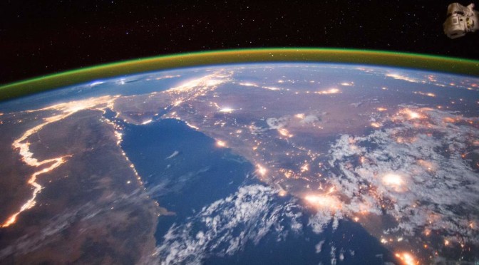
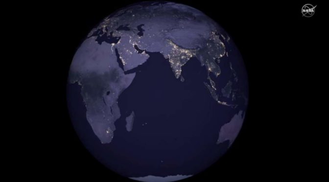
The first new global map of Earth from space at night since 2012 has been released by NASA scientists. The nighttime look of our planet is dubbed the “Black Marble”. But why?

On December 7, 1972, the crew of Apollo 17 spacecraft en route to the Moon took a photo of Earth from space, at a distance of about 45,000 kilometers (28,000 miles). This image, with the official NASA designation AS17-148-22727, became known as “The Blue Marble“.

In fact, it was not the first clear image of Earth taken from space – similar photos had already been taken as early as 1967. But, the 1970s were the scene of a big surge in environmental activism. For example, on April 22, 1970, the first “Earth Day” was organized by Gaylord Nelson, former senator of Wisconsin, and Denis Hayes, Harvard graduate student. Millions of people gather in the United States for the event.

Categories
Earth from Space Planet Earth Space Exploration

Jeff’s Earth [Amazing HD Video from the ISS]

On his most recent trip to the International Space Station (Expedition 48), recently-retired NASA astronaut Jeff Williams has recorded a great HD video of Earth (titled Jeff’s Earth) using an Ultra High Definition video camera.

Here in the video titled “Jeff’s Earth” below, he shares some of those images and talks about the beauty of the planet, the variety of things to see, and the value of sharing that perspective with everyone who can’t go to orbit in person.

Categories
Earth from Space Climate Space Exploration

GOES-16 Satellite delivers breathtaking Earth Images

The first set of images from the GOES-16 satellite (see notes 1) have been released by the National Oceanic and Atmospheric Administration (N0AA). In the video below, published by Space.com, you can see the amazing images of the Earth and the Moon.

Categories
Earth from Space Mars Planet Earth Space Exploration

Photo of Earth and Moon from Mars

NASA published an amazing image of Earth (and the Moon) from Mars, taken on November 20, 2016, by the High-Resolution Imaging Science Experiment (HiRISE) camera on NASA’s Mars Reconnaissance Orbiter. The image is so incredibly detailed that we can see even the continents and clouds of Earth.

Categories
Earth from Space Places Planet Earth Space Exploration

10 Most Beautiful Earth Images Taken From the International Space Station in 2016

Here are the top ten most beautiful Earth photos taken by the astronauts aboard the International Space Station (ISS) in 2016.

Categories
Earth from Space Space Exploration

A Year of Earth From a Million Miles Away [EPIC NASA video]

A year after returning its first image, NASA’s EPIC camera, a four-megapixel CCD camera, and telescope attached to the Deep Space Climate Observatory (DSCOVR) show us an entire year of Earth from a million miles away. The result is the amazing video below.

With the voice of Jay Herman, EPIC lead scientist.

Categories
Earth from Space Places Space Exploration

10 Most Beautiful Earth Images Taken From the International Space Station in 2015

The International Space Station (ISS) has been orbiting Earth since 1998, providing scientists and astronauts with a unique vantage point to observe and study our planet. In addition to its scientific mission, the ISS has also captured some of the most breathtaking images of Earth from space. In this article, we will take a look at the 10 most beautiful Earth images taken from the ISS in 2015. From stunning views of the Northern Lights to majestic mountain ranges and turquoise waters, these images remind us of the incredible beauty of our planet and the importance of protecting it for future generations.

Categories
Moon Landing Earth from Space Space Exploration

Photographs that were taken during the Apollo program [1966-1972] are now on Flickr, free to use

The Apollo program is a significant milestone in the history of space exploration. During the program, NASA sent astronauts to the moon and captured breathtaking photographs of the lunar surface and space. These photographs have been treasured by space enthusiasts and researchers alike for decades, and now, they are available for everyone to access. Thanks to a collaboration between NASA and Flickr, a vast collection of Apollo program photographs, spanning from 1966 to 1972, is now freely available on the photo-sharing platform. This unprecedented move allows people to explore and use these historic images in new and creative ways.

Categories
Space Exploration Earth from Space

Astronaut Chris Hadfield’s cover of Bowie’s Space Oddity [Video]

Canadian astronaut Chris Hadfield, the former commander of the International Space Station recorded a revised cover version of David Bowie’s famous song “Space Oddity” while floating on board. The incredible video clip contains great views of planet Earth and nice scenes inside the space station.

Categories
Earth from Space Space Exploration

EPIC Earth Image by NASA

At the Sun-Earth L1 Lagrangian point, 1,500,000 km (930,000 mi) from Earth; NASA’s Deep Space Climate Observatory took an amazing photo of the entire sunlit side of Earth on July 06, 20145. The photo was taken by NASA’s Earth Polychromatic Imaging Camera (EPIC), a four-megapixel CCD camera and telescope. An EPIC Earth image from space!

The final image showing North and Central America was generated by combining three separate images to create a photographic-quality image. The camera takes a series of 10 images using different narrowband filters — from ultraviolet to near-infrared — to produce a variety of science products. The red, green, and blue channel images are used in these color images.